Mitchell Kaminski
COLUMBIA, Mo. (KMIZ)
Missouri’s first month of legal sports betting generated heavy activity, but no money for education.
When Amendment 2, which legalized sports betting in Missouri, appeared on the ballot, one of its biggest supporters was the group Winning for Missouri Education. The group estimated the measure would generate $100 million in tax revenue over five years.
Under the amendment, a 10% tax on sports betting revenue is dedicated to education, but only after operators deduct expenses and contribute to the compulsive gambling prevention fund. However, what the group failed to mention is that the ballot language also allows for the possibility that no money would go to schools if taxable revenue is insufficient.
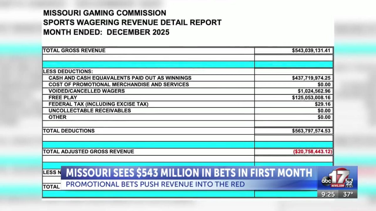
New figures from the Missouri Gaming Commission show sportsbooks took in more than $543 million in bets during their first full month of operation. After payouts, voided wagers and promotional credits, however, the state finished $20.8 million in the red, leaving no taxable revenue to distribute under Missouri’s constitution.
A key driver was sportsbooks’ aggressive promotional betting strategy to lure in customers.
Sportsbooks wrote off $125.1 million in free-play wagers, which are exempt from taxation under the constitutional amendment voters approved. FanDuel alone wrote off over $53 million in free-play wagers, while DraftKings wrote off $48.5 million.
Ryan Butler, senior news analyst at Covers.com, said the early numbers reflect strong interest and a familiar rollout strategy.
“The best way to look at it is per capita spent in the biggest population and Missouri’s was pretty stronger than North Carolina, which is the most recent comparable one,” Butler said.
Butler added one of the biggest unknowns, was whether Missourians would stick with sportsbook accounts they already used in neighboring states or if there was pent-up demand for betting legally at home. He said the early data shows it was the latter, with strong interest from bettors eager to place wagers without crossing state lines.
That excitement was fueled by costly promotions.
“The free bets were pretty ridiculous, where it was if the Chiefs or Texans score a single point in their game, or if the Blues have a shot on goal,” Butler said. “The promos were very expensive and this is common.”
According to the commission’s report, total deductions, including winnings paid out and free play, reached $563.8 million, exceeding total gross revenue. The result: negative adjusted gross revenue and essentially no tax collection tied to education.
“Because of these deductions and everything with it, the sportsbooks are able to then mitigate their tax liability if they declare losses because of these free bets,” Butler said. “It’s very usual for a state in their first month to spend a lot of money like this but it’s not going to continue.”
Butler said sportsbooks expected early losses and view promotions as a long-term investment.
“It’s an investment. It’s what they call a customer acquisition tool,” Butler said. “On their financial reports leading up to it they expected to lose $20 to $30 million that first month so it’s actually a little less than they expected to lose but again, they have shown us time and time again that they’re making money. MGM just came out with their financials and they had lost billions of dollars on these kind of strategies leading up to it and now they are turning a profit. They made $250 million last year.”
However, while Missouri finished in the red, Butler predicts that will change moving forward.
“There were no taxes basically that’s because of all these free bets and promos. But that is going to change,” Butler said. “We’re going to see it stabilize really beginning this month. Next month, there will be less betting handle, there will be less bets placed, but there’s going to be more taxes generated.”
Missouri’s launch comes a year after it missed out on Super Bowl betting entirely. During the Chiefs’ 2024 Super Bowl run, GeoComply says it blocked 431,000 attempts by Missouri devices trying to place legal bets in other states — nearly half targeting Kansas sportsbooks.
That cross-border betting paid off for Kansas. During the Chiefs’ 2023 playoff run, Kansas collected about $600,000 in sports betting revenue. In the 2024 playoffs, that figure jumped to $1.7 million.
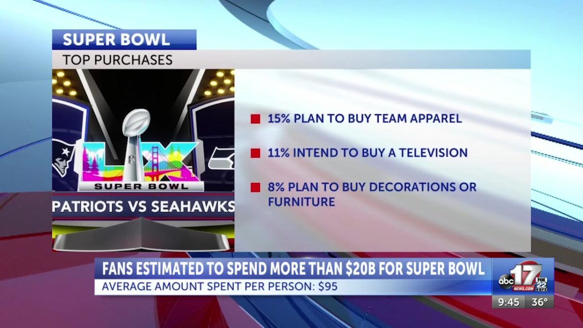
With the Super Bowl just two days away, sportsbooks are once again expecting large numbers.
“It’s two teams vying for the championship of the most popular sport betting sport in America,” Johnny Avello, DraftKings ‘ head oddsmaker, told ABC 17 News. ““At this point, with three days to go before the Super Bowl, things look pretty good. You know, kind of where we thought our expectations would be. But these next two days are crucial because that’s when some of the big bets and the big money comes in. Probably only 20% has been written, then there’s about 80% to go.”
Avello said sportsbooks dramatically expand offerings for the Super Bowl, with far more betting options than a typical NFL Sunday.
“Usually on a Sunday for every game we probably have about 600 props for each game,” Avello said. “For this 1500 this week. So yeah, we increase it.”
DraftKings is also running two major promotions tied to the game, similar to those used during its initial rollout, including an offer that allows bettors to share in a $4 million prize pool if they wager on a player to score who scores the game’s longest touchdown.
“We don’t normally do two on any given Sunday or anything of this big. But for the Super Bowl we think you know it’s worth doing and people are looking for them and plus all the other little ones that we do you know on a daily basis.”
However, some of the novelty props offered during the Super Bowl won’t be available to Missourians due to the state’s regulatory framework.
“Missouri won’t do coin toss, they won’t do Gatorade, they won’t even do some on-field ones,” Butler said. “The idea behind states such as Missouri that ban this is fear of manipulation.”
Butler said sportsbooks requested permission to offer certain bets, but the Missouri Gaming Commission reviewed those requests and declined them, opting for a stricter approach than some other states that have approved similar wagering options.
Click here to follow the original article.