Flood risk continues through Friday as a storm system brings numerous rounds of rain to the islands
By Pete Caggiano
Click here for updates on this story
HONOLULU (KITV) — A new storm system approaches and brings a flood risk through Friday.
Tonight, expect cloudy skies with temperatures in the upper 60 degrees. Rain is expected for Maui County and the Big Island.
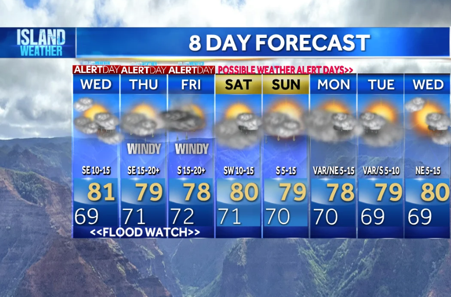
On Wednesday, mostly cloudy skies with scattered rain is forecast, mainly in the afternoon and evening. Some rains will be heavier. Winds will be from the south/east at 5 to 10 mph. High temperatures will be in the upper 70 degrees to near 80 degrees.
A Flood Watch goes into effect from 6 a.m. on Wednesday through Friday at 6 p.m.
Weather Alert Days are in effect from Wednesday to Friday due to the flood risk. Gusty Kona winds will also develop on Thursday and Friday. Expect winds gusts over 40 mph in some downslope spots as winds shift from the southeast to south from Thursday through Friday. Computer models indicate possible rainfall totals of 5 to 12 inches.
A Winter Storm Advisory is in effect for the summits of the Big Island.
Surf heights will increase: north-facing shores 6 to 10 feet, west-facing shores 5 to 7 feet, south-facing shores 6 to 10 feet, and east-facing shores 1 to 3 feet. High Surf Advisories possible for the south shores.
Please note: This story was provided to CNN Wire by an affiliate and does not contain original CNN reporting. This content carries a strict local market embargo. If you share the same market as the contributor of this article, you may not use it on any platform.