More progress brings lifted and lowered evacuation levels on the Cram Fire, two fires on the Warm Springs Reservation

Barney Lerten

(Update: Monday updates on Cram, Butte Creek and Greeley Heights fires; operations update)

ASHWOOD, Ore. (KTVZ) — More progress, helped by cooler weather, have brought reduced and removed evacuation levels Monday on the week-old, nearly 96,000-acre Cram Fire in Jefferson and Wasco counties and on the two new fires that broke out this weekend on the Warm Springs Indian Reservation.

The latest positive sign came Monday afternoon, first when the Wasco County Sheriff’s Office announced all evacuation levels had been lifted on their side of the county line.

Later, the Jefferson County Sheriff’s Office announced evacuation level reductions:

“Thanks to fire personnel working hard, containment has been brought to 73% and so many levels have experienced a reduction in evacuation status.

Jefferson County Evacuation Map

Currently no longer in an evacuation level:

NE 17

NE18

SE 19

Gateway

NE 9

NE 10 (west side of Emerson)

NE 12 (west side of Emerson all the way up)

Currently in a level one:

NE 12 (East side of Emerson)

NE 10 (East of Emerson)

NE 8 (top NE corner was in a level two 7/20)

SE 15 (west of Little Willow Creek Reservoir, this cut follows an odd shape through the area, please look at the web map for further details)

Currently in a level two:

NE 14 (a top NW portion)

NE 13 (west side split following outside burn perimeter, stays west of Hay Creek)

NE 16 (the split is a bit west of Tompkins Butte)

NE 15 (split is west of Gooseberry Mtn.)

No change to SE 16, SE 17 or SE 18.

The middle portions of NE 14, NE 13, NE 16 and NE 15 all remain in a level three around that Cram Fire Burn Perimeter.”

Per Jefferson County Sheriff’s Office on Facebook

Monday Cram Fire evacuation levels (Courtesy Jefferson County Sheriff’s Office)

On the Warm Springs Indian Reservation, evacuation levels were lowered Sunday afternoon to Level 1 BE READY on the Butte Creek Fire due to continued progress on stopping the fire that broke out Saturday and grew to cover 2,046 acres, according to information released Monday.

Here’s the Monday morning Cram Fire update:

Fire Information Line: (541) 216-7206Email 2025.cram@firenet.govInformation Resources: https://linktr.ee/cramfire2025

Size: 95,736 acres | Cause: Under Investigation | Total Personnel: 887| Containment: 73%

Madras, Ore. – With containment now at 73% and the threat to structures significantly reduced, the Cram Fire Unified Command (Northwest Complex Incident Management Team 10 and Oregon State Fire Marshal Green Team) will begin transitioning the management of the incident to Northwest Complex Incident Management Team 3 (NW Team 3). NW Team 3 will assume command of the Cram Fire and other nearby fires on Tuesday, July 22, following a full day of shadowing their counterparts today. The outgoing team members would like to thank the local community for their outpouring of support.

Yesterday, fire managers requested a reconnaissance flight to assess conditions across the fire. The flight revealed little to no heat within the interior or along the entire perimeter of the fire, rendering bucket work unnecessary. Available aerial resources were redirected to support the nearby Butte Creek and Greeley Heights fires.

Following field verification and conversations with landowners, fire personnel have been able to learn more about destroyed structures within the fire’s perimeter. After completing damage assessments in previously inaccessible terrain, structural firefighters determined that two structures previously identified as residences were actually outbuildings. Crews also discovered 12 additional destroyed outbuildings, such as barns, workshops, pump houses and sheds, bringing the total count of destroyed structures to 2 residences and 14 outbuildings.

Today, firefighters continue with the mopping up of hot spots and patrolling containment lines. Wildland crews on the east side of the fire, near Grater Butte, remain focused on fortifying constructed lines, increasing their width for additional assurance. Structural resources are gradually demobilizing as the threat to homes decreases.

Weather: Light showers may occur over the fire area today, with minimal accumulation expected. Thunderstorms may develop this afternoon with gusty winds. Tomorrow’s forecast calls for variable winds with isolated gusts.

Evacuations: Evacuations remain in effect, but some zones have recently been downgraded. Jefferson, Wasco and Crook County Sheriffs have issued Level 3 (GO NOW), Level 2 (BE SET), and Level 1 (BE READY) evacuations across multiple zones. Please refer to official evacuation maps for the most up-to-date info. Jefferson County: tinyurl.com/JCSOEvacMap, Wasco County: tinyurl.com/WascoCountyEvacMap, Crook County: tinyurl.com/CrookCountyEvacMap

Recreation/Closures: At this time, there are no closures to BLM land. Be advised that conditions may change at any time; before recreating, check local fire conditions and closures.

Smoke Outlook: An interactive smoke map for your area is available at https://fire.airnow.gov.

Safety: The public plays an important role in preventing the next wildfire; use caution with all ignition sources. For prevention tips, visit https://keeporegongreen.org.

Earlier story:

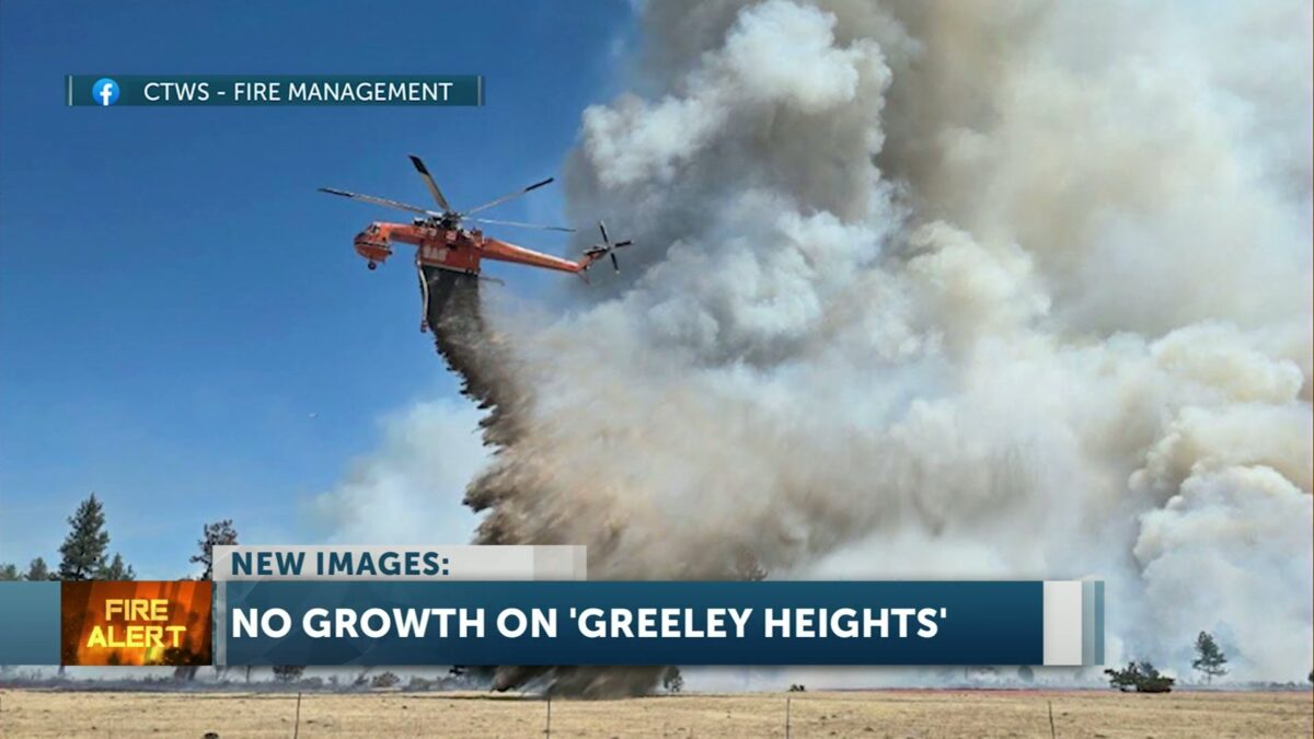
UPDATE: According to Watch Duty, there was no growth with the Greeley Heights Fire overnight. The fire remains at 381 Acres. The Cram Fire, is 49% contained and has burned 95,769 Acres.

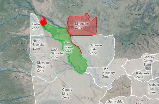
WARM SPRINGS, Ore. (KTVZ) – Two new wildfires broke out late Friday and Saturday on the Warm Springs Indian Reservation, prompting Level 3 GO NOW  evacuations of Simnasho and in the Greeley Heights area of Warm Springs and the closure for several hours of a more than 30-mile stretch of U.S. Highway 26. But major air and ground attacks brought lower evacuation levels on both fires by the end of the day.

The Butte Creek Fire was reported Friday night near Highway 26 and Simnasho Road, growing to 100 acres overnight, 1,200 acres by 4 p.m. and 1,756 acres before 9 p.m. Saturday, according to the National Interagency Fire Center. Track Watch Duty updates here.

The Warm Springs Police Department said in a Facebook post at mid-afternoon Saturday that Simasho, on the north side of the reservation, was at a Level 3 GO NOW evacuation level, while Schoolie Flats was at a Level 2 notice, meaning residents need to GET SET to evacuate at a moment’s notice. An area known as The Island was on a Level 1 GET READY evacuation notice. Track map updates here.

Highway 26 was closed at midday from milepost 71.5 to 96, later extending several miles, and ODOT advised travelers to use an alternate route. The highway reopened by 6:30 p.m. Follow ODOT’s TripCheck page for updates.

Later Saturday afternoon, a new fire, the Greeley Heights Fire, was reported southwest of Jackson Trail Road and Highway 26 in the Greeley Heights area of the Warm Springs community, prompting a Level 3 GO NOW evacuation on Mt. Jefferson Street.

The fire in Warm Springs was first reported to be six acres but quickly grew to nearly 400 acres by nightfall.

According to a 9:20 p.m. update from CTWS Fire Management, the Greeley Heights Fire had grown to 381 acres.

“Resources for both fires continue to be filled and are responding,” the agency said. “Both fires had many aerial hours of water and retardant drops, along with engines and hand crews fighting the fire.

“Winds continued to blow throughout the day from the northwest, with temperatures in the upper 80s,” they added.

There was good news on both fires late Saturday night, as Warm Springs Police reported that thanks to successful crew efforts and effective aerial suppression operations in the afternoon, fire activity significantly decreased on the Butte Creek Fire and also decreased in key areas of the Greeley Heights Fire.

As a result, evacuation levels in the Simnasho Zone of the Butte Creek Fire were downgraded from Level 3 GO NOW to Level 2 GET SET. While residents could return home, they were warned to remain alert and be ready to leave again at a moment’s notice, if conditions change.

On the Greeley Heights Fire, evacuation levels for the Mt. Jefferson Street area of the Greeley Heights Zone and the Jackson Trail Zone were downgraded to Level 1, BE READY.

Earlier closure of Hwy. 26; it has since reopened. Courtesy ODOT TripCheck

Courtesy SARTOPO

Meanwhile, there was better news Saturday on the nearly 96,000-acre Cram Fire in Jefferson and Wasco counties, now nearly 50% contained. Here’s the Saturday evening update from the fire’s Facebook page:

“The fire is now 95,769 acres, with just 138 acres of growth since last night. Thanks to the tireless work of firefighters, RFPA members, and landowners, containment has increased to 49%.

Crews continue to mop up and monitor the perimeter, extinguishing hot spots and reinforcing control lines.

❓What does containment mean?

Containment is the portion of the fire’s edge where crews are confident the fire will no longer spread beyond established control lines. These can be natural barriers like rivers or ridgelines, or constructed lines—created by dozers or hand crews—reinforced with water or fire retardant.

Thank you to everyone supporting this effort—on the fireline and in the community.

Earlier Cram Fire update:

Morning Update – Saturday, July 19, 2025 – 9:00 a.m.

Fire Information Line: (541) 216-7206 | Email: 2025.cram@firenet.gov Link Tree Resources: https://linktr.ee/cramfire2025

Size: 95,769 acres | Cause: Under Investigation | Total Personnel: 775

Madras, Ore. – A public meeting was held last night at Jefferson County Middle School, where fire managers and local officials shared updates and answered questions. A recording of the meeting will be posted on the Cram Fire Facebook page. The Jefferson County Sheriff’s Office has confirmed that the Cram Fire destroyed six structures, including four residences and two additional buildings.

Yesterday, fire activity moderated on the north side. Oregon State Fire Marshal task forces worked around homes, checking for heat and extinguishing hotspots. Crews are focusing efforts on limbing up fire-affected juniper trees near homes and mitigating hazardous fuels such as brush to prevent flare-ups and conducting mop-up. As crews make steady progress in the north, some personnel and equipment are being shifted to support areas of more intense fire activity, but firefighters are still maintaining a presence to ensure the safety of structures and conduct mop-up operations.

Fire behavior along the southeastern edge picked up again yesterday. Helicopters and airtankers dropped water and retardant to help slow the fire’s progression and give crews more time to prepare and strengthen control lines to the south. Crews and engines working the lines were supported by Rangeland Fire Protection Associations and were able to slow the fire’s spread to the south. As of yesterday, crews have established line around the entire fire and will be working in the coming days to solidify and strengthen the perimeter.

Today, firefighters remain actively engaged along the fire’s edge wherever conditions allow, keeping the fire from spreading toward values at risk such as communities, infrastructure, and natural resources. Work continues to protect and identify at-risk structures in and near the fire’s footprint. Dedicated aviation resources will continue to support by cooling hotspots and slowing fire spread, creating safer conditions for crews on the ground.

Weather: Cooler temperatures are forecast for the weekend and lower wind speeds will likely moderate fire behavior. Monday brings a slight chance of thunderstorms, which the incident meteorologist will be closely monitoring.

Evacuations: Evacuations remain in effect. Jefferson, Wasco and Crook County Sheriffs have issued Level 3 (GO NOW), Level 2 (BE SET), and Level 1 (BE READY) evacuations across multiple zones. Please refer to official evacuation maps for the most up-to-date info: Jefferson County: tinyurl.com/JCSOEvacMap, Wasco County: tinyurl.com/WascoCountyEvacMap, Crook County: https://tinyurl.com/CrookCountyEvacMap

Recreation/Closures: At this time, there are no closures to BLM land. Be advised that conditions may change at anytime; before recreating, check local fire conditions and closures.

Smoke Outlook: An interactive smoke map for your area is available at https://fire.airnow.gov.

Safety: Please drive carefully in fire-impacted areas. Crews and heavy equipment are working along roadways, and visibility may be reduced due to smoke.

Click here to follow the original article.

Prineville animal shelter celebrates long-awaited, hard-earned expansion with public event

Claire Elmer

PRINEVILLE, Ore. (KTVZ) — In Prineville, dozens of wagging tails are settling into a brand-new space…one that’s been nearly 10 years in the making. The Humane Society of the Ochocos (HSO) has officially opened its new dog wing, and marked the accomplishment with a grand opening event for the public.

The previous shelter was built in 1995 and was only meant to be temporary. Still, even with limited space and aging infrastructure, staff and volunteers made it work for nearly three decades. 

Rebecca Ott, president of the board of directors, told KTVZ News support from the community was crucial in the new wing. “We started with fundraisers—golf tournaments, casino night, adoption events. There’s been a lot of big donations and sponsors,” said Ott.

The new space includes 43 kennels, more room for animals and staff, and cleaner, quieter conditions for dogs who have already been through a lot. The dogs now have their own kennels, as opposed to the old building in which they needed to be doubled-up.

It’s a milestone made possible by years of dedication, community events, and local giving. It was all part of a long-term plan called “Vision 2020.” The goal: build a better shelter, one phase at a time.

Chanda Wallace, executive director of HSO, spoke at the ribbon-cutting. “As we celebrate phase one of our project, we remain hopeful and excited about the future. With your continued support, we can bring phases two and three to life,” said Wallace.

Phase two expands the cat wing and phase three includes a new administrative building. 

But on Saturday, the focus was on celebrating how far the shelter has come. For those who helped make it happen, the reward is greater than anything tangible.

Speakers during the event included both shelter staff and construction staff that worked together on the project. One speaker exclaimed to the crowd, “look how far we’ve come!” Another spoke of the team effort by saying, “it’s not about one person — it’s about everybody.”

The team at HSO says they’re just getting started. From spay and neuter programs to dog walking and fostering initiatives, they’re inviting the public to join the next chapter. You can visit their website here for more information on volunteering, fostering, donation needs, and more.

This new home is just the beginning…both for the animals, and the people working to give them a second chance.

Click here to follow the original article.

Old Mill Classic Cruz starts new tradition

Tyson Beauchemin

BEND, Ore. (KTVZ) — There’s a brand new classic car show happening this weekend in Bend. From 9 a.m. to 3 p.m. Saturday, the west side of the Old Mill will be filled with classic cars.

If you’re a classic car owner who’s just hearing about this, you’re in luck. Registration is still open. If the weather holds out, this might be a perfect way to start a weekend along the river.

One of the organizers, Ken Lucas, suggested, “If they feel like it, they could go across the street and rent a bike and go pedal around. They can go down to Bend Parks and Rec, get a kayak or float tube and float the river down to town.”

There’s no fee to swing by and see some cars and judging. The event runs from 9 a.m. to 3:30 p.m. The award event kicks off at noon and trophies will be handed out by 1 p.m. You can find more details on the Old Mill Classic Cruz website.

Click here to follow the original article.

Problem Solvers: Missed mail, illegal signs, fed-up residents: Why one Bend neighborhood may be a warning sign for others

Harley Coldiron

BEND, Ore. (KTVZ) — As one westside Bend neighborhood near Galveston and Century Drive grows with new construction and tourists, the Problem Solvers counted at least 25 illegal signs that neighbors have put up, warning people not to park in front of their mailboxes. However, they say it’s not because they want a convenient place to park, it’s about avoiding missed mail deliveries.

The Problem Solvers spoke with Julie, who’s lived in the neighborhood for a decade, and says finding a place to park has always been a problem: “They park here all the time. We live really close to Parilla and Taco Salsa, and it’s a hot lunch spot.”

The United States Postal Service confirmed these signs are not legal, and the use of their logo has not been permitted.

However, Julie and other neighbors, the Problem Solvers talked to stressed that the variety of no-parking signs people put up in front of their mailboxes, telling people they can’t park there, is so they don’t miss any mail deliveries.

“For some of our neighbors, which are our good friends, when someone parks in front of their house, they don’t get their mail. And we know our mailman – he’s been ours, the same guy for quite a number of years. And he gets very frustrated,” Julie said in an interview outside her home.

The Problem Solvers counted at least 25 signs in the neighborhood, which the U.S. Postal Service and the city of Bend say are not legitimate. The use of their official logo is illegal, and USPS confirmed they have not authorized its use for any signs in the neighborhood or in Bend.

KTVZ News asked the Postal Service several times what residents should do about people blocking their mailboxes.

The only solutions they gave were to leave a handwritten note on the person blocking their mailbox or to have a face-to-face conversation.

Neighbors said they did not see these options as a long-term solution, and pointed out that they can’t police their mailboxes 24/7. Others worried it could create potentially hostile and confrontational situations.

Another neighbor, Dana, says the parking issues are partly to blame on high-density housing, and new local and state laws that forbid minimum parking requirements for some developments.

Dana, like his fellow neighbors, supports new homes, but the issues that have arisen should be addressed: “It’s helpful to have, you know, high-density housing. But what’s the overall plan?” 

The laws from both the city and state aim to cut down on red tape and spur more badly needed housing.

“You know, per the state, onsite parking is considered valuable housing right now. So how do you find a balance where you still have affordable housing?”

Russ Grayson, who oversees operations for the city, says they’re aware of the issues in this and other neighborhoods: “A lot of that has to do with the redevelopment that is occurring in there. All the kind of, you can say attractions and draws on Galveston (Avenue), we’re seeing density increase”. 

Whether it’s adding a permit system or a time limit, it’s nearly impossible to make everyone happy.

“There’s always this push-pull relationship between parking strategies that we need to try to manage and balance,” Grayson said in an interview with the Problem Solvers.

No matter what happens, Carmen says she’ll always love the neighborhood: “I think the changes have all been good. You know, with parking, there’s always going to be growing issues.”

Click here to follow the original article.

Prison inmates from across Oregon brought to Deer Ridge to help ‘defend in place’ efforts from nearby Cram Fire

Barney Lerten

MADRAS, Ore. (KTVZ) — About 70 state prison inmates were brought in from around Oregon to perform field work to help “defend in place” Deer Ridge Correctional Institution from the Cram Fire, which is about 2 1/2 miles from the medium-security facility, the Oregon Department of Corrections told KTVZ News on Friday.

DRCI, which houses nearly 1,100 inmates, is continuing fire preparedness and response efforts, including bringing the adults in custody (AICs) from other DOC locations who have been deployed to Deer Ridge, agency Communications Manager Amber Campbell told us.

“These crews are actively working in the field on targeted areas identified by the State Fire Marshal’s Office Liaison,” she said. “This includes work to reinforce fire lines and address fuel reduction needs. Their efforts are focused and strategic, based on the latest recommendations from our fire partners.”

KTVZ News Chief Meteorologist John Carroll said while the Cram Fire perimeter is about 2.5 miles northeast of the prison, aggressive firefighting and line-building efforts have kept it from moving any closer to the prison since earlier in the week.

Campbell told us in a statement, “DRCI remains under a Red Flag Warning, and while there is currently no direct threat to the facility, we are taking all necessary precautions All normal operations will continue at this time, apart from visiting, which has been canceled for the weekend to allow for proactive planning and reduce risk in the event of shifting wind conditions.”

“DRCI participates in the community Incident Command System (ICS) briefings,” she said. “DRCI has thorough emergency preparedness plans for evacuation and a plan to defend in place.”

Asked why out-of-area inmates were brought in for that work, rather than assign Deer Ridge inmates, Campbell told us, “While DRCI is a minimum-security facility, not all minimum classified adults in custody (AICs) are approved to leave the facility. Additionally, not all AICs are trained to perform fire crew duties. These 70 are AICs who have had fire crew training and been medically cleared for this type of work.”

Air scrubbers have been deployed throughout the institution, Campbell said, while DOC Health Services has triaged medically fragile AICs to determine the proper levels of care (on-site, off-site or transfer to another DOC facility if needed) for those individuals. 

Click here to follow the original article.

With wildfires, smoke affecting Oregon highways, summer travelers are urged to plan ahead, prepare and stay informed

Barney Lerten

 SALEM, Ore. (KTVZ) — As wildfires continue to impact parts of Oregon, Governor Tina Kotek has declared a State of Emergency, effective July 16, 2025, through December 31, 2025. Travelers are urged to use extra caution on the roads and know the conditions in the areas they are traveling to.

Smoke can severely reduce visibility and create dangerous driving conditions. In some areas, wildfire activity has led to road closures or detours.

The Oregon Department of Transportation (ODOT), Oregon Department of Emergency Management (OEM), and Oregon Department of Environmental Quality (DEQ) are working together to keep Oregonians safe—and they’re asking the public to do their part before hitting the road. 

“If you’re planning a road trip this summer, make sure your car is ready,” OEM spokesperson, Erin Zysett, said. “Start your trip with a full tank of gas or electric charge, check your tires and air conditioner, and know your route. Conditions can change quickly during wildfire season.” 

OEM urges travelers to carry a well-stocked emergency car kit in case they become stranded or delayed. Your kit should include: 

Jumper cables 

Flares or a reflective triangle 

Flashlight and extra batteries 

First aid kit 

Blanket 

Map or printed directions 

Cell phone and car charger 

Backup power supply 

Hand-crank Weather Radio 

N95 mask (to help filter smoky air)  

Plastic sheeting and duct tape (to shelter in place if needed) 

Wet wipes, garbage bags, and toilet paper for sanitation 

Whistle to signal for help 

Water and non-perishable snacks 

Cash or traveler’s checks 

Portable shovel 

“Smoke affects visibility, as well as air quality, and can lead to sudden changes in driving conditions,” said Chris Varley, DEQ Spokesperson. “If visibility is poor or the air is hazardous, consider delaying your trip. Your safety comes first. If you must drive in smoky conditions, close all the windows and direct the car’s air system to recirculate, to help reduce the amount of smoke entering the car.” 

Before You Go: 

Check road closures and conditions at https://tripcheck.com 

Monitor air quality at Oregon Smoke Information 

View active wildfire maps and evacuation levels at https://wildfire.oregon.gov 

Sign up for OR-Alert messages at https://oralert.gov 

Enable Wireless Emergency Alerts (WEA) on your phone 

Pack and emergency kit 

 Visit https://wildfire.oregon.gov to learn more about how to be ready for fire season. 

Click here to follow the original article.

Fairwell Festival in Redmond, new exit route added to ease traffic

Jillian Fortner

(update: adding new exit information from Sheriff’s Office)

REDMOND, Ore. (KTVZ) — Tens of thousands of people are in Redmond for the third annual Fairwell Festival at the Deschutes County Fairgrounds.

“It takes a tremendous amount of time to get ready for this, fantastic team that works almost year-round of making this happen,” said Geoff Hinds, executive director of the Deschutes County Fairgrounds.

Despite concerns about nearby wildfires and air quality, no changes to the festival had been announced as of midday Friday.

Temperatures are expected to be warm this weekend, so it’s important to stay cool and hydrated during the outdoor event.

Hinds said, “There’s a ton of shade, misting tents, free water stations here on grounds. Make sure you come prepared for being out in the sun.”

Local and state law enforcement will have extra patrols in the area. With traffic congestion expected, attendees are encouraged to allow extra travel time and consider using ridesharing or carpooling if possible.

Deschutes County Sheriff’s Office has been working with organizers to improve Saturday night’s exit experience. Here’s what they shared on Facebook: 

An alternative exit route from the fairgrounds to Highway 126 will be available for those heading to Bend. Additional staff will be on-site to assist with directions.

SW Airport Way will be closed to all inbound traffic, except for rideshare, guest pickup and airport-bound vehicles entering from Highway 97 and SW Veterans Way.

The festival runs through Saturday.

Click here to follow the original article.

Man seeking ‘fresh start’ accused of arson, setting SUV on fire north of Bend that spread to nearby trailer

Barney Lerten

BEND, Ore. (KTVZ) — A resident of a small homeless encampment north of Bend was arrested on arson and other charges Friday, accused of setting a vehicle fire that spread to a nearby trailer and trees.

Deschutes County 911 dispatchers received a report just after 8 a.m. of a fire near milepost 131 on Highway 97, just south of Deschutes Junction, sheriff’s office Public Information Officer Jason Carr said.

Bend Fire crews arrived quickly and were able to knock the flames down before they could spread further, Carr said, adding that no injuries were reported.

Sheriff’s deputies determined that Charles Smith Harris Jr., 55, allegedly set fire to an SUV, which then spread to another man’s nearby trailer, Carr said. The fire also ignited several small trees in the area.

Harris was booked into the county jail on charges of first-degree arson, reckless burning, first-degree criminal mischief, second-degree criminal trespass and second-degree disorderly conduct.

Harris was cooperative with deputies, Carr said, and reportedly told them he started the fire in an attempt to “get a fresh start.”

Carr told KTVZ News Harris and the trailer owner “knew each other because of living near each other,” but that no altercation occurred.

Harris claimed the SUV was his, but Carr told us there’s “some question as to who owns it.”

It was the second arson arrest to occur north of Bend in less than a day. Jodie Wakeman, a resident of Green Acres RV Park south of Redmond, is accused of setting her trailer ablaze, a fire that spread to two other RVs and killed a dog.

Carr said the two crimes were not related.

Click here to follow the original article.

Pedaling toward progress: City of Bend launches bike-share as eco-friendly transportation option

Claire Elmer

(Update: Adding video)

BEND, Ore. (KTVZ) — You may have seen new black and teal e-bikes popping up around Bend recently. They’re part of a new bike-share program the city of Bend has implemented. The city partnered with Veo, the independent shared micro-mobility company, earlier this month.

The city rolled out 300 of the pedal-assist e-bikes across Bend. They can be rented using a mobile app and left at designated bike racks or “parking zones” once the ride is over.

The goal is to add more sustainable options for people to get around town.

City Councilor Ariel Mendez said, “This was a council initiative. Part of the reason that we did this is because they would replace a lot of car trips. That means that there’s more parking available, less congestion.”

The bikes may be getting people out of their cars, but not everyone is thrilled with where they’re ending up. Users are expected to ride responsibly and park consciously.

“We don’t want to see these blocking sidewalks or parked inappropriately. They should be parked out of the way,” said Mendez.

While many agree it’s a good idea in theory, the way the bikes have been left also brings about mixed reactions. Noah Cable, a tourist visiting from Portland, is familiar with bike-share programs.

As a small-business owner, Cable has experienced both the pros and cons that come with them.

“On one side, it’s a really great program. It’s great for community involvement. It gets people riding on bikes. It gets cars off the street. On the other hand, they’re kind of left around, like litter a little bit,” said Cable.

Hopes are high that with a little courtesy and common sense, the program will be a success. “I wish everybody was a tiny bit more responsible with them. But I love the program, and I think it’s really spectacular. You know, be a responsible bike rider, everybody! You know what to do – and wear a helmet,” said Cable.

The Bend City Council encourages feedback from the public and asks that if you see an issue, you report it to either the council or Veo. You can email the council at council@bendoregon.gov and find contact information for Veo on their app.

But whether you’re out exploring, downtown commuting, or just wanting to try something new, the bike-share program is now up and rolling for you to try. 

Click here to follow the original article.

Six structures lost to explosive Cram Fire, now approaching 100,000 acres: One resident shares story

Isabella Warren

(Update: Adding video, comments from neighbor)

ASHWOOD, Ore. (KTVZ) — Residents living in the Ashwood community are grappling with the loss of structures after the over 95,000-acre Cram Fire started this week.

The fire that began last Sunday has exploded in size day after day as fire crews struggle to establish containment and protect homes. According to the National Interagency Fire Center, as of Friday morning’s daily situation report (PDF), six structures have been destroyed.

Kyle Butler lives near Ashwood and has seen the devastation. He says his neighbor, Lynn Alps, lost her home in the flames.

“Firefighters told us with Lynn’s house, they fought it on every front, every front they possibly could. It came from four different ways. And they tried to stop it,” said Butler. “And it just got to a point where it was coming up a draw, and there was nothing they could do.”

Butler says he hopes to help Alps as she tries to rebuild with a fundraiser.

“It’s someone’s life. It’s their whole home, everything, their memories, their sentimental values, everything that they’ve collected over however many years. And it’s all gone within a day. “

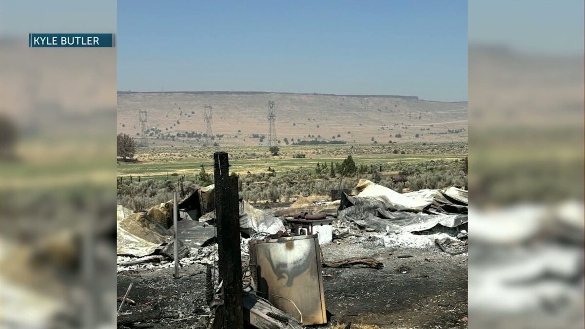
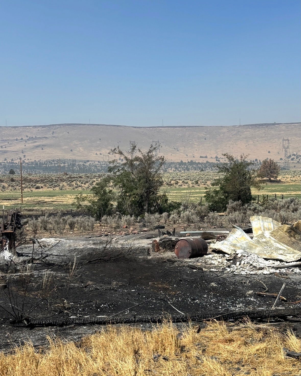
Lynn Alps home after the Cram Fire burned near AshwoodCredit: Kyle Butler
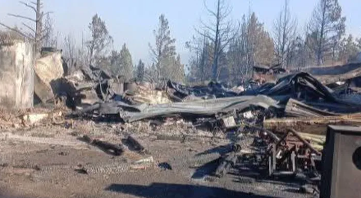
KTVZ News has also learned a family has lost a barn in the fire. According to the family’s GoFundMe page, “My grandparents lost almost everything in the Cram Fire. Their barn — full of tools, equipment, food stores, and supplies they built up over a lifetime — is completely gone. They also lost some of their livestock. They were lucky to escape with their lives.”

Credit: GoFundMe

Residents in the area have told KTVZ News that many of them have not evacuated the area of Ashwood, despite the Level 3 evacuation notice. They say instead, they are defending their homes and properties, with the help of their own equipment and structure firefighters stationed in the area.

Click here to follow the original article.