Prescribed burns across Central Oregon: how agencies track smoke and protect air quality
Tracee Tuesday
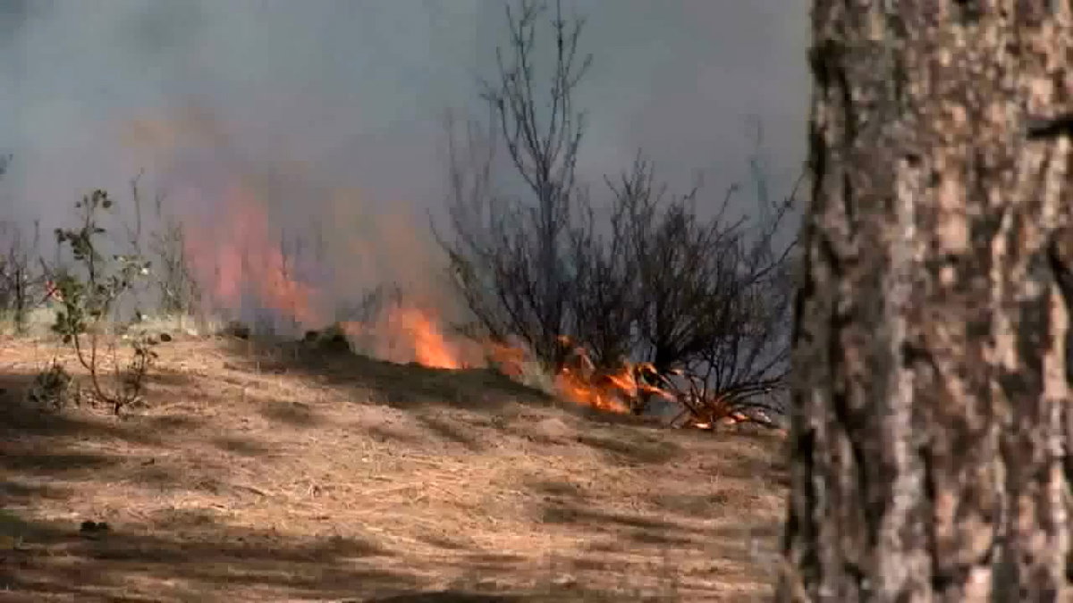
BEND, Ore. (KTVZ) — As prescribed burning ramps up across Central Oregon, state and local agencies say a combination of real-time monitoring, weather modeling and community planning is key to limiting smoke impacts in Bend and surrounding areas.
The Oregon Department of Forestry (ODF) relies on meteorologists who track air quality using Department of Environmental Quality (DEQ) monitors statewide, including several in Bend. Those readings help guide decisions before and during burns and alert officials to any developing smoke concerns.
Each day, ODF issues detailed forecasts that break the state into “smoke zones,” outlining when and where burning can safely occur. Meteorologists also consult directly with burn managers when there is concern smoke could drift into populated areas.
A major focus is how smoke behaves once it rises.
Forecasters analyze “mixing height,” or how high smoke can lift into the atmosphere, along with wind direction and transport patterns. The higher and farther smoke travels, the less likely it is to concentrate near the ground where people live.
DEQ works alongside ODF and federal partners to determine when conditions are safe enough to ignite prescribed burns. Before any burn is approved, agencies review meteorological data, smoke modeling and local conditions to ensure air quality standards are protected.
State rules are designed to protect “Smoke Sensitive Receptor Areas,” including communities like Bend, by limiting smoke exposure to no more than one hour. Officials say even small amounts of smoke can affect vulnerable groups, including older adults, infants and people with heart or lung conditions.
Despite careful planning, weather can shift unexpectedly. When smoke lingers longer than expected, local health agencies step in with community response plans to notify residents and reduce exposure.
Deschutes County Health Services says those impacts are usually short-lived and often happen overnight.
“Limit their exposure to smoke. And so during prescribed fire season, those smoke impacts are typically they’re occurring overnight. They’re limited in duration. People are not as likely to be exposed to that smoke,” said Community Health Specialist Sarah Worthington. “And so our primary recommendation in conjunction with prescribed fire smoke is really to close your windows to stay informed so that you’re aware that there may be smoke impacts overnight.”
Officials emphasize that prescribed burns, while sometimes smoky, are a preventative tool meant to reduce the risk of larger, more dangerous wildfires that can create prolonged and hazardous air quality conditions.
Residents can track active and planned burns through the state’s daily burn map and monitor local air quality through DEQ’s online dashboard.
Central Oregon forests are seeing more prescribed burns this time of year as land managers work to reduce wildfire risk—but those intentional fires also raise questions about air quality and public health. KTVZ’s Tracee Tuesday is taking a closer look at how agencies juggle the need to burn safely with the need to keep the air clean.
Each prescribed burn starts with a careful forecast. Fire managers check wind direction, temperature, humidity, and atmospheric inversions to decide whether smoke will rise and disperse—or settle over towns and neighborhoods. On days when conditions aren’t right, burns are often postponed or canceled to avoid impacting communities.
The Oregon Department of Forestry, Oregon Department of Environmental Quality, and Deschutes County Health Services work together to balance wildfire‑risk reduction with air‑quality and public‑health concerns. State foresters design burn plans and coordinate with smoke specialists, while DEQ monitors air quality and helps determine when smoke levels could pose health concerns. County health officials then use that information to advise sensitive groups—like children, older adults, and people with respiratory conditions—on how to limit exposure.
Tracee has reached out to the aforementioned agencies to learn more about how they manage air quality around prescribed burns, how they communicate with the public, and what residents should watch for when the smoke is visible. A full report will air during the 4 p.m. newscast on KTVZ’s FOX affiliate, with details on how these partners plan ahead—and what you can do when the air gets smoky.
If you’ve seen smoky skies or captured video or photos of a prescribed burn in your area, we want to see it. Send your images and short clips to stories@KTVZ.com and we may feature them in our coverage of prescribed burns and air quality in Central Oregon.
Firefighters on the Deschutes National Forest are planning prescribed burning operations on the Bend-Fort Rock and Sisters Ranger Districts for Monday, if weather conditions remain favorable.
These planned burns aim to connect with prior units to create strategic holding features and protect homes from potential future wildfires.
The Sisters Ranger District intends to conduct ignitions on up to 171 acres within the SAFR 271 and 274 Prescribed Burn units. These units are located approximately one mile west of Sisters along the south side of Forest Service Road 15, across from the Crossroads subdivision. Ignitions for this area are planned for 9:30 a.m.
Concurrently, the Bend-Fort Rock Ranger District plans to conduct up to 145 acres of ignitions on the Thor eight Prescribed Burn unit. This unit is situated six miles northeast of La Pine, adjacent to McKay Crossing Campground on the north side of Paulina Creek, with ignitions scheduled for 10:30 a.m.
Fire management officials work with Oregon Department of Forestry smoke specialists to plan these prescribed burns, which are conducted when weather conditions are most likely to move smoke up and away from communities.
While no road or trail closures are anticipated for most areas, the public is asked to avoid trails in the vicinity of the Sisters burn. People driving along Forest Service Road 15 should slow down and use caution, as firefighting personnel will be working along the roadway and smoke impacts are expected. Edgington Road and other Forest Service roads in the area may also experience smoke impacts.
Smoke from the Sisters area burn will be very visible from Sisters, the Crossroads subdivision and the Tollgate subdivision. Residents in these areas and the surrounding community are encouraged to keep doors and windows closed, particularly overnight and in the early morning hours, to minimize smoke impacts.
Smoke from the La Pine area burn will be visible from Highway 97, La Pine and Sunriver. Residents in Newberry Estates, La Pine and the surrounding areas are also encouraged to keep doors and windows closed to minimize smoke impacts during the overnight and early morning hours.
The Peter Skene Ogden Trail will be closed between Ogden Group Camp and 10 Mile SnoPark during the prescribed burn operations. This closure will extend for up to one week following the burn while mop-up and patrol operations continue. Firefighters will reopen trails once conditions have been assessed and are determined safe for the public.
During prescribed burns, smoke may settle in low-lying areas overnight and in early morning hours. All residents are encouraged to close doors and windows at night to avoid smoke impacts. Portable air cleaners or DIY air cleaners can be used in conjunction with closed doors and windows. Central air systems should use high-efficiency filters if available. When driving in smoky areas, drivers should slow down, turn on headlights and set their air to recirculating. Individuals with heart or lung disease, asthma or other chronic conditions should monitor their symptoms and consider contacting a health care professional if their symptoms worsen.
The Peter Skene Ogden Trail is expected to remain closed for up to one week following the prescribed burn for mop-up and patrol operations. Firefighters will reopen the trail once conditions are assessed and determined safe for the public.