More progress brings lifted and lowered evacuation levels on the Cram Fire, two fires on the Warm Springs Reservation

Barney Lerten
(Update: Monday updates on Cram, Butte Creek and Greeley Heights fires; operations update)
ASHWOOD, Ore. (KTVZ) — More progress, helped by cooler weather, have brought reduced and removed evacuation levels Monday on the week-old, nearly 96,000-acre Cram Fire in Jefferson and Wasco counties and on the two new fires that broke out this weekend on the Warm Springs Indian Reservation.
The latest positive sign came Monday afternoon, first when the Wasco County Sheriff’s Office announced all evacuation levels had been lifted on their side of the county line.
Later, the Jefferson County Sheriff’s Office announced evacuation level reductions:
“Thanks to fire personnel working hard, containment has been brought to 73% and so many levels have experienced a reduction in evacuation status.
Jefferson County Evacuation Map
Currently no longer in an evacuation level:
NE 17
NE18
SE 19
Gateway
NE 9
NE 10 (west side of Emerson)
NE 12 (west side of Emerson all the way up)
Currently in a level one:
NE 12 (East side of Emerson)
NE 10 (East of Emerson)
NE 8 (top NE corner was in a level two 7/20)
SE 15 (west of Little Willow Creek Reservoir, this cut follows an odd shape through the area, please look at the web map for further details)
Currently in a level two:
NE 14 (a top NW portion)
NE 13 (west side split following outside burn perimeter, stays west of Hay Creek)
NE 16 (the split is a bit west of Tompkins Butte)
NE 15 (split is west of Gooseberry Mtn.)
No change to SE 16, SE 17 or SE 18.
The middle portions of NE 14, NE 13, NE 16 and NE 15 all remain in a level three around that Cram Fire Burn Perimeter.”
Per Jefferson County Sheriff’s Office on Facebook
 Monday Cram Fire evacuation levels (Courtesy Jefferson County Sheriff’s Office)
On the Warm Springs Indian Reservation, evacuation levels were lowered Sunday afternoon to Level 1 BE READY on the Butte Creek Fire due to continued progress on stopping the fire that broke out Saturday and grew to cover 2,046 acres, according to information released Monday.
Here’s the Monday morning Cram Fire update:
Fire Information Line: (541) 216-7206Email 2025.cram@firenet.govInformation Resources: https://linktr.ee/cramfire2025
Size: 95,736 acres | Cause: Under Investigation | Total Personnel: 887| Containment: 73%
Madras, Ore. – With containment now at 73% and the threat to structures significantly reduced, the Cram Fire Unified Command (Northwest Complex Incident Management Team 10 and Oregon State Fire Marshal Green Team) will begin transitioning the management of the incident to Northwest Complex Incident Management Team 3 (NW Team 3). NW Team 3 will assume command of the Cram Fire and other nearby fires on Tuesday, July 22, following a full day of shadowing their counterparts today. The outgoing team members would like to thank the local community for their outpouring of support.
Yesterday, fire managers requested a reconnaissance flight to assess conditions across the fire. The flight revealed little to no heat within the interior or along the entire perimeter of the fire, rendering bucket work unnecessary. Available aerial resources were redirected to support the nearby Butte Creek and Greeley Heights fires.
Following field verification and conversations with landowners, fire personnel have been able to learn more about destroyed structures within the fire’s perimeter. After completing damage assessments in previously inaccessible terrain, structural firefighters determined that two structures previously identified as residences were actually outbuildings. Crews also discovered 12 additional destroyed outbuildings, such as barns, workshops, pump houses and sheds, bringing the total count of destroyed structures to 2 residences and 14 outbuildings.
Today, firefighters continue with the mopping up of hot spots and patrolling containment lines. Wildland crews on the east side of the fire, near Grater Butte, remain focused on fortifying constructed lines, increasing their width for additional assurance. Structural resources are gradually demobilizing as the threat to homes decreases.
Weather: Light showers may occur over the fire area today, with minimal accumulation expected. Thunderstorms may develop this afternoon with gusty winds. Tomorrow’s forecast calls for variable winds with isolated gusts.
Evacuations: Evacuations remain in effect, but some zones have recently been downgraded. Jefferson, Wasco and Crook County Sheriffs have issued Level 3 (GO NOW), Level 2 (BE SET), and Level 1 (BE READY) evacuations across multiple zones. Please refer to official evacuation maps for the most up-to-date info. Jefferson County: tinyurl.com/JCSOEvacMap, Wasco County: tinyurl.com/WascoCountyEvacMap, Crook County: tinyurl.com/CrookCountyEvacMap
Recreation/Closures: At this time, there are no closures to BLM land. Be advised that conditions may change at any time; before recreating, check local fire conditions and closures.
Smoke Outlook: An interactive smoke map for your area is available at https://fire.airnow.gov.
Safety: The public plays an important role in preventing the next wildfire; use caution with all ignition sources. For prevention tips, visit https://keeporegongreen.org.
—
Earlier story:
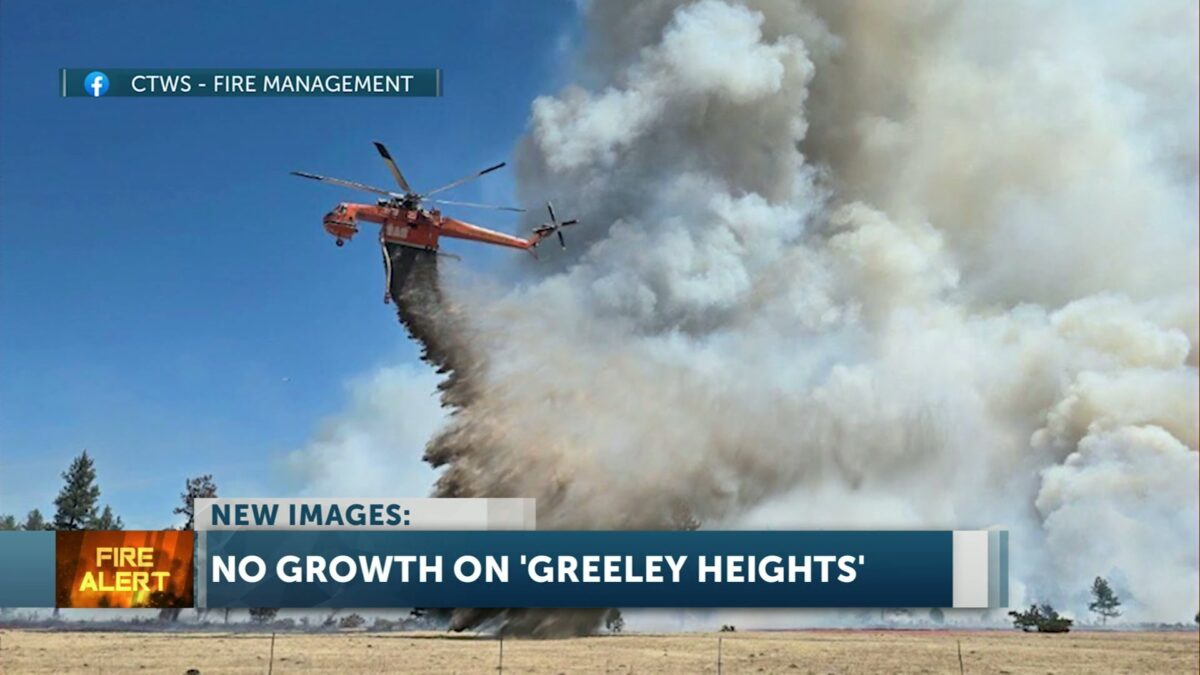
UPDATE: According to Watch Duty, there was no growth with the Greeley Heights Fire overnight. The fire remains at 381 Acres. The Cram Fire, is 49% contained and has burned 95,769 Acres.
WARM SPRINGS, Ore. (KTVZ) – Two new wildfires broke out late Friday and Saturday on the Warm Springs Indian Reservation, prompting Level 3 GO NOW evacuations of Simnasho and in the Greeley Heights area of Warm Springs and the closure for several hours of a more than 30-mile stretch of U.S. Highway 26. But major air and ground attacks brought lower evacuation levels on both fires by the end of the day.
The Butte Creek Fire was reported Friday night near Highway 26 and Simnasho Road, growing to 100 acres overnight, 1,200 acres by 4 p.m. and 1,756 acres before 9 p.m. Saturday, according to the National Interagency Fire Center. Track Watch Duty updates here.
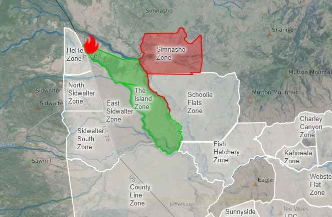
The Warm Springs Police Department said in a Facebook post at mid-afternoon Saturday that Simasho, on the north side of the reservation, was at a Level 3 GO NOW evacuation level, while Schoolie Flats was at a Level 2 notice, meaning residents need to GET SET to evacuate at a moment’s notice. An area known as The Island was on a Level 1 GET READY evacuation notice. Track map updates here.
Highway 26 was closed at midday from milepost 71.5 to 96, later extending several miles, and ODOT advised travelers to use an alternate route. The highway reopened by 6:30 p.m. Follow ODOT’s TripCheck page for updates.
Later Saturday afternoon, a new fire, the Greeley Heights Fire, was reported southwest of Jackson Trail Road and Highway 26 in the Greeley Heights area of the Warm Springs community, prompting a Level 3 GO NOW evacuation on Mt. Jefferson Street.
The fire in Warm Springs was first reported to be six acres but quickly grew to nearly 400 acres by nightfall.
According to a 9:20 p.m. update from CTWS Fire Management, the Greeley Heights Fire had grown to 381 acres.
“Resources for both fires continue to be filled and are responding,” the agency said. “Both fires had many aerial hours of water and retardant drops, along with engines and hand crews fighting the fire.
“Winds continued to blow throughout the day from the northwest, with temperatures in the upper 80s,” they added.
There was good news on both fires late Saturday night, as Warm Springs Police reported that thanks to successful crew efforts and effective aerial suppression operations in the afternoon, fire activity significantly decreased on the Butte Creek Fire and also decreased in key areas of the Greeley Heights Fire.
As a result, evacuation levels in the Simnasho Zone of the Butte Creek Fire were downgraded from Level 3 GO NOW to Level 2 GET SET. While residents could return home, they were warned to remain alert and be ready to leave again at a moment’s notice, if conditions change.
On the Greeley Heights Fire, evacuation levels for the Mt. Jefferson Street area of the Greeley Heights Zone and the Jackson Trail Zone were downgraded to Level 1, BE READY.
 Earlier closure of Hwy. 26; it has since reopened. Courtesy ODOT TripCheck
 Courtesy SARTOPO
—
Meanwhile, there was better news Saturday on the nearly 96,000-acre Cram Fire in Jefferson and Wasco counties, now nearly 50% contained. Here’s the Saturday evening update from the fire’s Facebook page:
“The fire is now 95,769 acres, with just 138 acres of growth since last night. Thanks to the tireless work of firefighters, RFPA members, and landowners, containment has increased to 49%.
Crews continue to mop up and monitor the perimeter, extinguishing hot spots and reinforcing control lines.
 What does containment mean?
Containment is the portion of the fire’s edge where crews are confident the fire will no longer spread beyond established control lines. These can be natural barriers like rivers or ridgelines, or constructed lines—created by dozers or hand crews—reinforced with water or fire retardant.
Thank you to everyone supporting this effort—on the fireline and in the community.
Earlier Cram Fire update:
Morning Update – Saturday, July 19, 2025 – 9:00 a.m.
Fire Information Line: (541) 216-7206 | Email: 2025.cram@firenet.gov Link Tree Resources: https://linktr.ee/cramfire2025
Size: 95,769 acres | Cause: Under Investigation | Total Personnel: 775
Madras, Ore. – A public meeting was held last night at Jefferson County Middle School, where fire managers and local officials shared updates and answered questions. A recording of the meeting will be posted on the Cram Fire Facebook page. The Jefferson County Sheriff’s Office has confirmed that the Cram Fire destroyed six structures, including four residences and two additional buildings.
Yesterday, fire activity moderated on the north side. Oregon State Fire Marshal task forces worked around homes, checking for heat and extinguishing hotspots. Crews are focusing efforts on limbing up fire-affected juniper trees near homes and mitigating hazardous fuels such as brush to prevent flare-ups and conducting mop-up. As crews make steady progress in the north, some personnel and equipment are being shifted to support areas of more intense fire activity, but firefighters are still maintaining a presence to ensure the safety of structures and conduct mop-up operations.
Fire behavior along the southeastern edge picked up again yesterday. Helicopters and airtankers dropped water and retardant to help slow the fire’s progression and give crews more time to prepare and strengthen control lines to the south. Crews and engines working the lines were supported by Rangeland Fire Protection Associations and were able to slow the fire’s spread to the south. As of yesterday, crews have established line around the entire fire and will be working in the coming days to solidify and strengthen the perimeter.
Today, firefighters remain actively engaged along the fire’s edge wherever conditions allow, keeping the fire from spreading toward values at risk such as communities, infrastructure, and natural resources. Work continues to protect and identify at-risk structures in and near the fire’s footprint. Dedicated aviation resources will continue to support by cooling hotspots and slowing fire spread, creating safer conditions for crews on the ground.
Weather: Cooler temperatures are forecast for the weekend and lower wind speeds will likely moderate fire behavior. Monday brings a slight chance of thunderstorms, which the incident meteorologist will be closely monitoring.
Evacuations: Evacuations remain in effect. Jefferson, Wasco and Crook County Sheriffs have issued Level 3 (GO NOW), Level 2 (BE SET), and Level 1 (BE READY) evacuations across multiple zones. Please refer to official evacuation maps for the most up-to-date info: Jefferson County: tinyurl.com/JCSOEvacMap, Wasco County: tinyurl.com/WascoCountyEvacMap, Crook County: https://tinyurl.com/CrookCountyEvacMap
Recreation/Closures: At this time, there are no closures to BLM land. Be advised that conditions may change at anytime; before recreating, check local fire conditions and closures.
Smoke Outlook: An interactive smoke map for your area is available at https://fire.airnow.gov.
Safety: Please drive carefully in fire-impacted areas. Crews and heavy equipment are working along roadways, and visibility may be reduced due to smoke.