Cram Fire grows to nearly 96,000 acres, closer to ‘megafire’ status; widespread evacuations continue
Isabella Warren
(Update: Friday update, community meeting, operations briefing)
ASHWOOD, Ore. (KTVZ) — The Cram Fire raging in Jefferson and Wasco counties has grown even closer to the 100,00-acre “megafire” status, as more hot, dry winds challenge the growing army of firefighters and evacuations continue, officials said Friday.
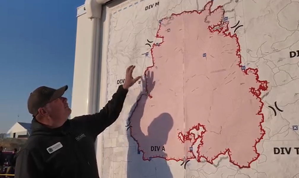
During Friday evening’s community meeting at Jefferson County Middle School (a recording is available on the Jefferson County Sheriff’s Office Facebook page), officials advised that the fire had grown to an estimated size of over 95,600 acres.
Here’s Friday’s full 9 a.m. Cram Fire Update:
Information Line: (541) 216-7206 | Email: 2025. cram@firenet. gov Resources Link: https://linktr.ee/cramfire2025
Size: 94,293 Acres | Cause: Under Investigation | Total Staff: 730
Madras, Ore. – A community meeting is scheduled for today, Friday, July 18, 2025 at 5:30 p.m. at Jefferson Middle School located at 1180 SE Kemper Way in Madras. The board will be available to watch live on the Jefferson County Sheriff’s Facebook page.
Yesterday, north of the fire around Sand Hallow and Tub Springs canyons, little activity was observed. Firefighters continued to patrol the Line of Control and search for hot spots around structures to reinforce their containment efforts.
The team in charge advises the needs by positioning units in priority areas. Units east of the fire continued to patrol, extinguishing hotspots and protecting structures.
Upon completing line built by heavy excavators southeast of the fire, excavators were assigned to begin building line south of the fire from west to east along Ashwood Street. Fire front pushes south towards the intersection of Hay Creek and E streets. Ashwood and also towards the Trout River area.
Units of forest and structure fire that were available were sent to help, supported by aircraft sending water from the sky. Efforts to tackle this blaze were challenged by the weather. Near the Trout River, smoke and heat continue to be a challenge for units working to limit the fire’s movement southward. During last night’s shift, firefighters patrolled and monitored areas of growth.
Today, firefighters will continue to secure lines and extinguish hot spots south of Highway 293. In the southern perimeter, units will reinforce and open the line finished by excavators from the west to the steppara improve the line and its ability to contain the fire.
Weather: Red Flag Warning is in effect today until 10 p.m. due to dry conditions and strong winds. Starting tomorrow, a cold front will move through the weekend that will bring low temperatures and high humidity. Forecast shows increased chance of rain for Monday or Tuesday; not enough to extinguish the fire.
Evacuations: Evacuations are still in effect. Jefferson and Wasco Counties Sheriffs have extended Level 3 (Leave Now), Level 2 (Ready) and Level 3 (Prepare) evacuations in several areas. Please check official evacuation maps for latest information: Jefferson: County: tinyurl.com/JCSOEvacMap Wasco County: tinyurl.com/WascoCountyEvacMap.
Smoke Forecast: An interactive map of smoke in your area is available at https:/ /fire.airnow.gov.
Warnings: Please drive with caution in fire-affected areas. Crews and heavy excavators are working alongside roads and smoke is reducing visibility.
Officials’ definition of a megafire is a wildfire that has burned 100,000 acres or more.
A public meeting will be held Friday evening at 5:30 PM at the Jefferson County Middle School to provide an update on the Cram Fire.
Representatives from the Incident Management Team, fire agencies, and local officials will share the latest information on fire behavior, current operations, evacuation levels, and available resources. Community members will have an opportunity to ask questions and hear directly from those managing the incident.
The meeting will also be livestreamed on the Jefferson County Sheriff’s Office Facebook page.
—
Late Thursday afternoon, Crook County announced a Level 1 GET READY evacuation level, becoming the third county affected by the blaze. They posted:
“CRAM FIRE UPDATE 4:00pm
Crook County Emergency Management is closely monitoring the Cram Fire, currently burning in Jefferson County.
Due to the fire’s progression and proximity to the county line, the Crook County Sheriff’s Office has issued LEVEL 1 “BE READY” evacuation notices for parts of northern Crook County. Affected areas include:
Foley Butte
North of the 27 Road to Ochoco Divide on Highway 26
This is a precautionary measure to ensure residents are prepared should conditions worsen.
Crook County Emergency Management will continue to coordinate with Jefferson County officials and provide updates as the situation develops.
For the most current information and updates:
Follow the Crook County Sheriff’s Office Facebook page
Use emergency alert apps such as Genasys or WatchDuty
Please stay alert, prepared, and safe.”
—
Earlier story:
The pace of growth had slowed a bit on Wednesday from the day before, reaching over 77,000 acres.There are 573 personnel assigned to this incident, with more on the way. That includes 92 engines, six hand crews and two helicopters.
Isabella Warren returned to the fire zone for live updates Thursday on KTVZ+ and on KTVZ News at 5:00 p.m.
Here’s fire officials’ Thursday morning update:
Cram Fire: Size: 77,163 acres | Cause: Under Investigation | Total Personnel: 573
Madras, Ore. – Northwest Complex Incident Management Team 10 (NW Team 10), under the leadership of Incident Commander Steve North, joined a Unified Command of the Cram Fire with the Oregon State Fire Marshal (OSFM) Green Team at 6 a.m. today. NW Team 10 spent the day shadowing their counterparts from the High Desert Type 3 Incident Management Team yesterday to ensure a seamless transition and continued coordination with the OSFM Green Team. This effort is part of a strong interagency partnership among local, state, and federal responders working together to protect lives, property, and natural resources.
The northern part of the fire, along Oregon Route 293, exhibited decreased fire activity yesterday, allowing firefighters to continue securing the line, mopping up hot spots and patrolling in that area. In anticipation of today’s Red Flag Warning, crews focused on structure protection, and aviation operations continued in areas of increased heat. On the southern portion of the fire, heavy equipment was utilized to complete and connect together unfinished fire lines. During the night shift, two additional strike teams of engines patrolled and mopped up to ensure those lines held through the night while personnel further bolstered structure protection. Strategic firing operations were successfully implemented to remove unburned fuel east of Hay Creek between NE Old US Highway 97 and the fire’s edge.
Today, firefighters will focus on mopping up around structures in areas of minimal or no current fire activity. North of East Ashwood Road, ground personnel working closely with aerial support, are constructing line directly on the fire’s edge where conditions allow. Fire managers continue to evaluate terrain, fire behavior and hazards to determine the safest and most effective tactics. Crews will monitor expected dynamic fire behavior throughout the day and focus on strengthening containment lines and tying together unconnected sections.
Weather: A Red Flag Warning is in effect today from 1 p.m. to 10 p.m. for dry and windy conditions. Winds will shift to the northwest, increasing to 10-15 mph with gusts up to 25 mph possible. Winds are expected to decrease overnight but may increase again on Friday before the passage of a cold front this weekend, which will bring cooler temperatures and higher humidity.
Evacuations: Evacuations remain in effect. Jefferson and Wasco County Sheriffs have issued Level 3 (GO NOW), Level 2 (BE SET), and Level 1 (BE READY) evacuations across multiple zones. Please refer to official evacuation maps for the most up-to-date info: Jefferson County: tinyurl.com/JCSOEvacMap, Wasco County: tinyurl.com/WascoCountyEvacMap.
Smoke Outlook: An interactive smoke map for your area is available at https://fire.airnow.gov.
Safety: Please drive carefully in fire-impacted areas. Crews and heavy equipment are working along roadways, and visibility may be reduced due to smoke.
In a Wednesday evening update on the fire’s Facebook page, officials said, “Fire activity was less than expected today due to decreased winds. However, fire behavior still produced challenges for personnel on the ground. Crews provided point protection around structures. With a red flag warning for high winds and low humidity in tomorrow’s forecast, firefighters focused on strengthening containment lines.”
Earlier updates:
Officials have confirmed to KTVZ News that the fire was human-caused, while the specific cause remains under investigation.
Crews have had some success in stopping or slowing the fire near Lower Tub Spring Road and around the power transmission lines, as well as in the community of Ashwood.
But the fire is expected to grow substantially again on Wednesday with the expected afternoon wind shift.
Isabella Warren returned to the fire zone Wednesday for more on-the-scene coverage and reports on KTVZ News at 5:00 p.m.
Here’s the latest Wednesday morning update on the blaze from Central Oregon fire officials:
The Cram Fire remained active throughout the night, pushed by low humidity and strong northeast winds up to 16 mph. Night shift crews were heavily engaged, conducting point protection and structure patrols on the west side of the fire, where residential areas and key infrastructure remain at risk.
Wildland crews supported the Rangeland Fire Protection Association (RFPA) with burnout operations to connect containment lines on the north side of the fire.
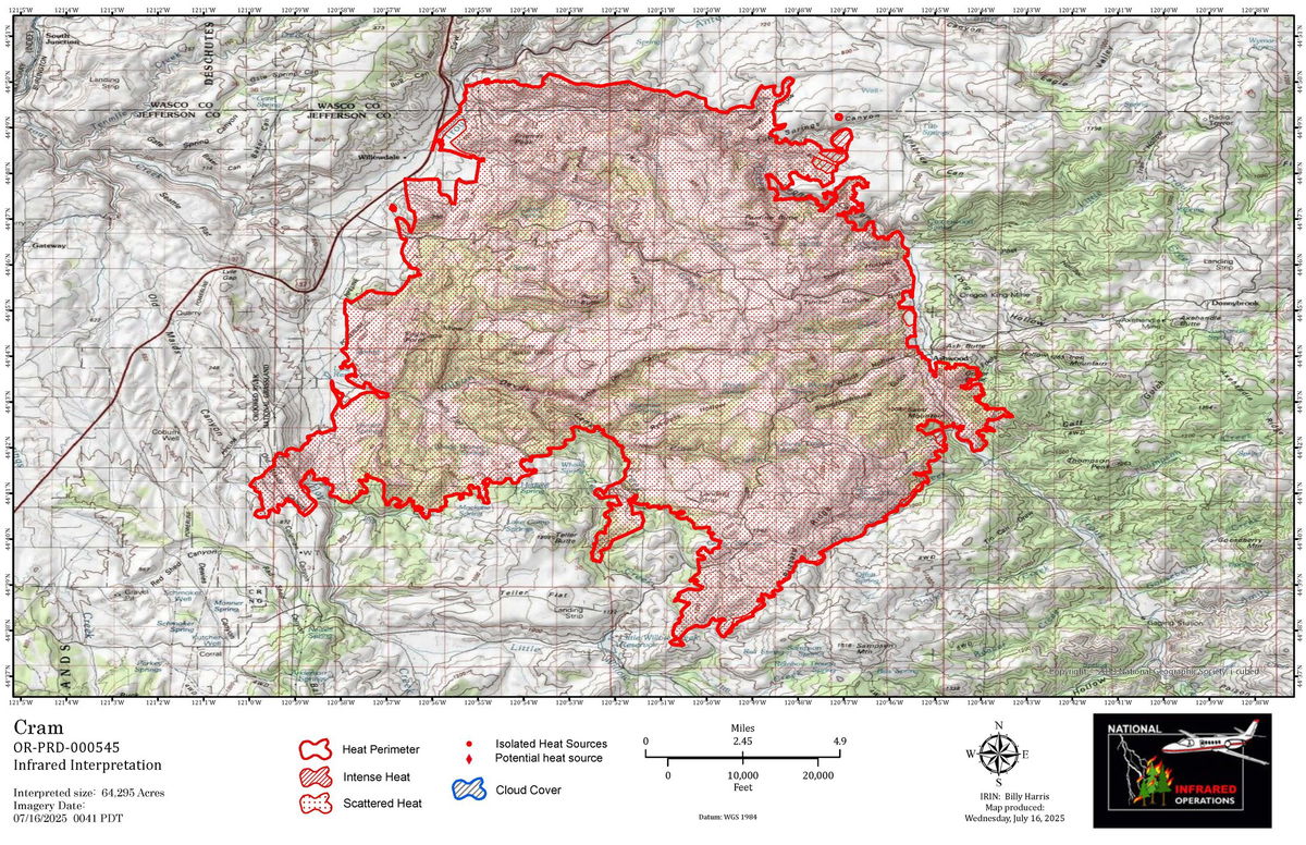
As fire activity increased on the southern flank of the fire, firefighters worked on protecting threatened structures and building containment lines. The fire continues to challenge containment efforts, and it is approximately 64,295 acres after the infrared flight last night.
Fire managers expect continued fire growth and activity today, with windy conditions persisting and a shift in wind direction expected by early afternoon, which could further test containment lines. Crews are preparing for dynamic fire behavior throughout the day. Firefighters will continue to strengthen containment lines and tie unconnected sections together.
The Wolf Creek Hotshots arrived yesterday to support suppression efforts, following the demobilization of the Prineville Hotshots earlier in the day. Oregon State Fire Marshal’s structural task forces remain engaged in structure protection and working to secure structures in and around the entire fire perimeter, working closely with local departments and wildland crews.
The High Desert Type 3 Incident Management Team continues in Unified Command with the Oregon State Fire Marshal’s (OSFM) Green Incident Management Team. Today, they will be shadowed by Northwest Complex Incident Management Team 10, which will enter into Unified Command with OSFM Green Team beginning Thursday. This transition ensures a seamless handoff and sustained incident support as suppression efforts continue.
Evacuations Remain in Effect:Jefferson and Wasco County Sheriffs have issued Level 3 (GO NOW), Level 2 (BE SET), and Level 1 (BE READY) evacuations across multiple zones.
✅ Please refer to official evacuation maps for the most up-to-date info:
Jefferson County: tinyurl.com/JCSOEvacMap
Wasco County: tinyurl.com/WascoCountyEvacMap
More Information:
Official fire updates: centraloregonfire.org and https://www.facebook.com/CramFire2025
X/Twitter: @CentralORfire
Smoke/air quality: fire.airnow.gov
To report a fire: Call 9-1-1
Please stay alert, follow official evacuation notices, and drive carefully in fire-impacted areas. Smoke may reduce visibility and crews may be working near roadways—help keep everyone safe by staying aware.
Information on all fires in Central Oregon will be posted on the only official source for wildfire information in Central Oregon at centraloregonfire.org or on X/Twitter @CentralORfire. Call 9-1-1 to report a wildfire. For smoke and air quality information, visit fire.airnow.gov.
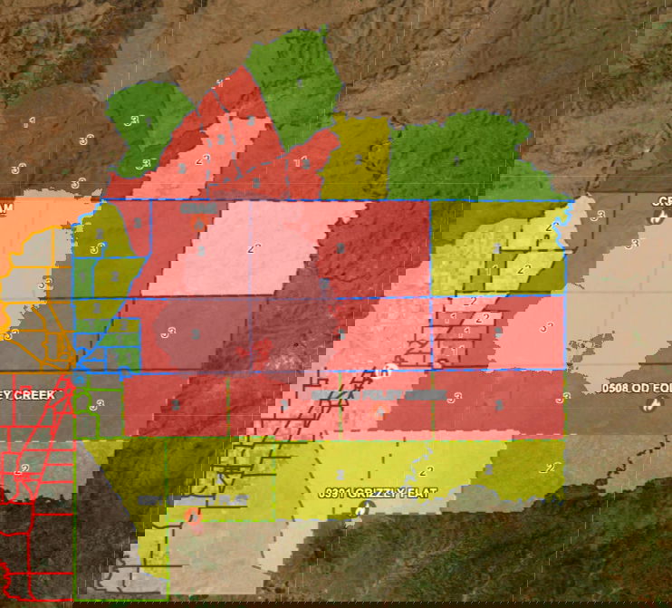 Jefferson, Wasco and Crook counties Cram Fire evacuation map, levels as of Friday morning
—
As of Wednesday morning, the Cram Fire has cost $3.2 million to fight, according to the National Interagency Fire Center’s daily Situation Report.
Earlier information:
Jefferson County Sheriff’s Office:
Evacuation level changes!
Due to the fire headed west with the potential to jump Hwy 97, NE 12 is on a LEVEL 3 GO NOW 3 evacuation level.
Red Cross is stationed at Jefferson County Middle School.
Large Animals can go to the Jefferson County Fairgrounds until Friday.
NE 12 surrounds the Gateway area. Some of these zones area larger in size so please utilize the map:
https://fr911orgis.maps.arcgis.com/…/weba…/index.html…
-use the search bar to locate your address.
-NE=North East area of Jefferson County.
-this will expand to the west of the zones already in place.
-NE 12 expands as far down as part of NE Quaale, and the part of NE Juniper ln. that meets NE Gateway Grade.
-the top of this zone meets to top border of Jefferson County.
—
Here’s Tuesday morning’s update, posted on the fire’s new Facebook page:
Yesterday saw significant fire growth on the Cram Fire as changing wind directions and rugged, steep terrain challenged fire resources.
As the fire advanced southeast, it reached the community of Ashwood, prompting a significant shift in suppression priorities. All available engines were redirected from fire line work to structure protection, and firefighters worked through the night to protect homes, outbuildings, and community infrastructure.
Firefighters conducted strategic firing operations around Ashwood to lessen the impacts of uncontrolled fire hitting the community and homes.
The Prineville Interagency Hotshots, BLM, Oregon Department of Forestry engines and Ashwood-Antelope Rangeland Fire Protection Association (RFPA) members worked alongside OSFM task forces around homes to light defensive backfires through the night to protect structures.
Last night, following the invocation of the Conflagration Act, the Oregon State Fire Marshal Green Team and High Desert Type 3 Incident Management Team out of eastern Oregon joined in unified command of the Cram Fire. A Complex Incident Management Team has been ordered and is expected to in-brief this evening.
The Cram Fire is burning on private land protected by the Ashwood-Antelope Rangeland Fire Protection Association and Prineville BLM managed land and is now 28,635 acres, with 0% containment.
The fire jumped Trout Creek and ran up Ranger Butte and is now moving to the southeast. The fire is burning in steep and rugged country, with few roads and challenging access.
Today’s priorities will be structure protection and scouting for opportunities to construct containment lines.
The eight structural task forces with resources from Linn, Lane, Marion, Multnomah, Washington, and Yamhill counties will continue to be actively engaged in protection around structures. Air resources will be available for fire managers, both to cool hot spots but also to use tactical retardant drops by aerial support to slow the spread of the fire along potential control lines.
Temperatures are expected to be lower today, but conditions remain dry and receptive to ignition.
________________________________________
Evacuations Remain in Effect:
Jefferson and Wasco County Sheriffs have issued Level 3 (GO NOW), Level 2 (BE SET), and Level 1 (BE READY) evacuations across multiple zones.
Please refer to official evacuation maps for the most up-to-date info:
• Jefferson County: tinyurl.com/JCSOEvacMap
• Wasco County: tinyurl.com/WascoCountyEvacMap
Information on all fires in Central Oregon will be posted on the only official source for wildfire information in Central Oregon at centraloregonfire.org or on X/Twitter @CentralORfire. Call 9-1-1 to report a wildfire. For smoke and air quality information, visit fire.airnow.gov.
—
Governor Kotek Invokes Conflagration Act for the Cram Fire
Fire in Jefferson and Wasco counties marks the sixth conflagration this wildfire season
Salem, OR — On the afternoon of July 14, 2025, Governor Tina Kotek invoked the Emergency Conflagration Act for the Cram Fire in Jefferson and Wasco counties. The Jefferson County Commission requested assistance with life, safety, and structural fire protection, and the state fire marshal concurred with that request.
Following ORS 476.510-476.610, Governor Kotek determined that a threat to life, safety, and property exists due to the fire, and the threat exceeds the firefighting capabilities of local firefighting personnel and equipment.
The Governor’s declaration allows the Oregon State Fire Marshal (OSFM) to mobilize resources through the Oregon Fire Mutual Aid System to support local fire service agencies on scene. The conflagration was invoked only for the Highland Fire, threatening structures in Jefferson and Wasco counties.
A link to Executive Order 25-15 can be found here.
The Oregon State Fire Marshal is sending its Green Incident Management Team and four task forces to provide structure protection and additional help. The task forces are from Lane, Multnomah, Washington, and Yamhill counties.
The Oregon Department of Forestry (ODF) has deployed all aviation assets available in the Central Oregon District to the Cram Fire through the agency’s Severity Program. ODF continues to support local, state and federal partners in wildfire suppression efforts with resources supplied through mutual aid agreements.
The Jefferson and Wasco County Sheriffs are overseeing evacuations in the affected area. Community members are urged to stay informed about evacuation levels and be prepared to act quickly. For the latest evacuation information, click here. To sign up for alerts in your area, click here.
This marks the sixth time the Emergency Conflagration Act has been invoked by Governor Kotek in the 2025 wildfire season.
—
Earlier story:
A fast-moving wildfire broke out Sunday evening near Highway 97 and Willowdale northeast of Madras, tearing through grass, brush, timber and leftover logging debris. It more than doubled in size to an estimated 28,000 acres Tuesday, prompting Level 3 GO NOW evacuations in Jefferson and Wasco counties and Levels 2 and 1 in other areas. No progress has been reported on containment as of the latest updates.
The Cram Fire was first reported by the National Interagency Fire Center at 5:32 p.m. Sunday, and as of Monday morning grew to an estimated 4,500 acres with 0% containment.
Just before 5 p.m. came this update from the Jefferson County Sheriff’s Office:
“Temporary Shelter is Madras Middle School; this has been changed from MHS.
Large animals can go to Jefferson County Fairgrounds, but must be picked up Friday due to the Fair. This hopefully gives you extra time to find arrangements, if by chance the fire is still ongoing by then. Thank you for understanding.”
And a half-hour later:
UPDATE!!!
“Hay Creek Road is no longer an option, please use Gosner Road if you are coming from Ashwood and the surrounding area.”
—
Shortly before 4 p.m., the Oregon State Fire Marshal issued this update on the state assist to firefighting efforts:
State fire marshal mobilizing resources, IMT to Cram Fire in Jefferson, Wasco countiesOregon State Fire Marshal – 07/14/25 3:42 PM
SALEM, Ore. – The Oregon State Fire Marshal is mobilizing resources to a fast-moving wildfire in Jefferson and Wasco counties. The Cram Fire, reported Sunday off Highway 97 at Willowdale, has grown to an estimated 10,000 acres, according to fire managers. On Monday, the Cram Fire was pushed by gusty winds and temperatures in the mid-90s, prompting levels 1, 2, and 3 evacuation notices in both counties.
The Oregon State Fire Marshal is sending its Green Incident Management Team and four task forces to provide structure protection and additional help. The task forces are from Lane, Multnomah, Washington, and Yamhill counties.
“The next 24 hours will be extremely challenging for this fire with continued gusty, shifting winds and hot temperatures,” State Fire Marshal Mariana Ruiz-Temple said. “This is the sixth time the Emergency Conflagration Act has been invoked this summer and comes as a reminder that we need everyone’s help to stay wildfire aware and prevent new fire starts.”
Resources from the Willowdale and Ashland Rural Fire Protection Associations, the Bureau of Land Management, and the Oregon Department of Forestry are actively working to stop the fire.
The Oregon State Fire Marshal Green Incident Management Team will be briefed Monday at 7 p.m.
For evacuation information:
Jefferson County: https://tinyurl.com/JCSOEvacMap
Wasco County: https://perimetermap.com/wascocounty-or/incidents/polygon/64222
Drivers are asked to slow down and follow all signs from the Oregon Department of Transportation along Highway 97. Fire crews are using the highway for active firefighting, and smoke may reduce visibility.
Delays and heavy smoke along Highway 97 are expected as crews move to battle the fire. Pony Butte Road is currently closed. Officials are recommending those leaving Ashwood to use Hay Creek Road.
Forest Service Deputy Ranger Kassidy Kern told KTVZ News on Monday the fire remains 0% contained, and somewhat cooler overnight temperatures didn’t slow it down, making for another challenging day for crews.
Monday’s elevated temperatures and gusty winds were challenging the day’s suppression efforts.
KTVZ’s Isabella Warren has been on the scene of the Cram fire and will have a full report tonight on KTVZ News at 5:00 p.m.
Jefferson County Sheriff’s Office update at 3 p.m. Monday:
Temporary Shelter is at Madras High School at 390 SE 10th St.
Evacuation levels have changed!
Ashwood, NE 16 and NE 13 have all been placed on a level 3, GO NOW! Evacuation.
The red zones are our level 3 zones.
Please use Hay Creek Road for evacuations; Pony Butte is not safe at this time.
As you leave, please drive with caution for there could be fire personnel in the area and visibility from smoke could be a problem.
Map: https://fr911orgis.maps.arcgis.com/…/weba…/index.html…
The Wasco County Sheriff’s Office also issued Level 3 GO NOW evacuations Monday afternoon, as well as Level 2 GET SET and Level 1 GET READY zones to the east.