Evacuation alert lowered to Level 2 on 50-acre Pine Fire in SE Crook County as lines hold overnight
KTVZ – News Team
(Update: Evacuation level lowered, lines hold overnight)
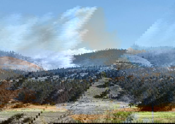
POST, Ore. (KTVZ) — Firefighters working through the night held the lines on the 50-acre Pine Fire that broke out Wednesday in southeastern Crook County, sheriff’s deputies said Thursday morning as the evacuation alert was lowered from Level 3 GO NOW to Level 2 GET SET in the area.
Here’s the sheriff’s office’s 9 a.m. update:
Fire crews worked through the night, successfully holding the fire lines. While there is still fire activity within the established perimeter, crews are making steady progress in containing it. Helicopters, engines, dozers, and personnel remain active in the area. For everyone’s safety, please avoid the area as suppression efforts continue.
Crook County Emergency Management will continue to work with the Fire Incident Command and provide information as it comes in. Continue to monitor the Crook County Sheriff’s Office Facebook page, Genasys, and Watch Duty for any updates.
POST, Ore. (KTVZ) August 13 — A new fire, named the Pine Fire, broke out Wednesday afternoon southeast of Post in Crook County’s Maury Mountains and quickly grew to about 50 acres, prompting a Level 3 GO NOW evacuation in the area.
The Level 3 evacuation was issued for Zone CRR-7S-E by the Crook County Sheriff’s Office. The zone can be viewed on the Watch Duty map & on the Genasys Evacuation Map.
The sheriff’s office said the evacuated area is on SE Pine Creek Road (Forest Service Road 17), south of Pine Creek Reservoir to the FS RD 17/150 spur.
 Level 3 GO NOW evacuation zone (Map courtesy Crook County Sheriff’s Office)
Central Oregon fire officials issued this fact sheet:
UPDATED: 8/13/25 3:33 p.m.
Start Date: August 13 at 12:18 p.m.
Location: 44°05’28.9″N 120°24’13.7″W
Between the Maury Mountains and Hwy 380, along Pine Creek Road
Jurisdiction: BLM Prineville District, Crook County
Fire Size: Approximately 20 acres. Fire behavior has moderated. Crews are making good progress.
Cause: Under investigation
Fuels: grass, juniper and timber. Increasing fire activity and torching
Structures: no structures threatened
Fire Crews/Resources: 3 engines, 2 dozers, air attack, 2 Type 1 helicopters, 6 SEATS (Single Engine Air Tankers), 1 Type 1 helicopter, 2 eight-person hand crews, 2 Type 2 IA crews, the local RFPAs (Rangeland Fire Protection Associations), and the La Grand Hotshots have been ordered.
Visit the official source for wildfire information in Central Oregon at centraloregonfire.org for wildfire updates or follow fire information on X/Twitter @CentralORfire. Call 9-1-1 to report a wildfire. For smoke and air quality information, visit fire.airnow.gov.
UPDATE: New information from the Crook County Sheriff’s Office was posted on Facebook concerning the Pine Fire.
CCSO Emergency Management is on scene of the Pine Fire located on SE Pine Creek Road (Forest Service Road 17) in Post. Currently, there is a 20+ acre fire actively burning. CCSO Emergency Management is working closely with Forest Service Fire Incident Command and monitoring the growth of the fire.
Currently, there are ground crews, dozers, skidgens, and air attack on scene.
At this time the fire is burning on Forest Service land and there are no threats to any subdivisions out in the Post area. We ask that the general public avoid the area due to the large volume of fire personnel and equipment in the area.
BEND, Ore. (KTVZ) — A new wildfire, named the Pine Fire, is burning an estimated 20 acres in Crook County as of Wednesday afternoon.
The fire is located near NF-17, south of the Paulina Highway.
Details about the fire’s cause and containment are limited at this time.
No structures are immediately threatened, and no evacuations have been ordered.
Stay with the platforms of KTVZ News for urgent updates as more information becomes available.
Another fire, the Glass Butte Fire, broke out on BLM Prineville District-managed land in Lake County. Here’s the fact sheet on that fire:
FOR IMMEDIATE RELEASE: August 13, 2025
UPDATED: 8/13/2025 4:11 p.m.
Start Date: August 13 at 1:27 p.m.
Location: 44°02’17.5″N 121°18’30.6″W
South of Hwy 20 near Glass Butte area
Jurisdiction: BLM Prineville District, Lake County
Fire Size: 5 acres. Fire behavior is active with a low rate of spread.
Cause: Under investigation
Fuels: grass, brush and sage
Structures: no structures threatened
Fire Crews/Resources: 5 engines, 1 dozer, 1 load of smoke jumpers, air attack, 4 SEATS (Single Engine Air Tankers) and 2 helos have been ordered,
Visit the official source for wildfire information in Central Oregon at centraloregonfire.org for wildfire updates or follow fire information on X/Twitter @CentralORfire. Call 9-1-1 to report a wildfire. For smoke and air quality information visit fire.airnow.gov.