Only Level 1 evacuation zone remains on the nearly 2-week-old , 96,000-acre Cram Fire
Barney Lerten
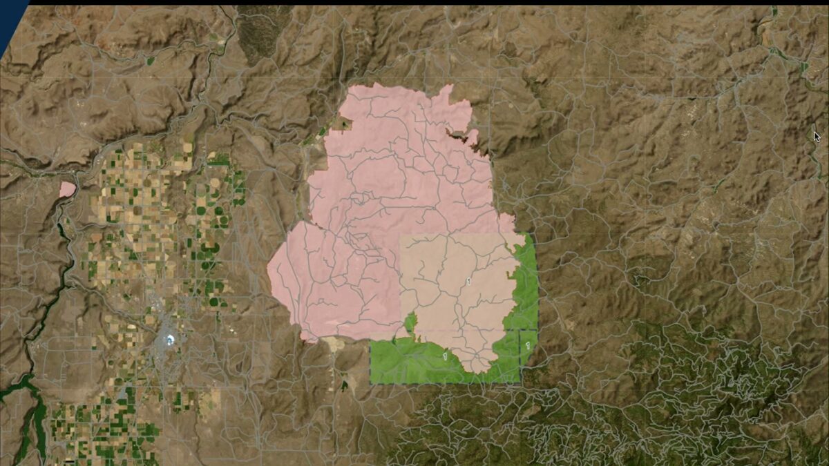
ASHWOOD, Ore. (KTVZ) — The Jefferson County Sheriff’s Office on Friday removed the last Level 3 GO NOW and Level 2 GET SET evacuation zones on the nearly 2-week-old Cram Fire that blew up to cover nearly 96,000 acres. A small area along the fire’s perimeter is stil at Level 1 GET READY.
Here’s what the sheriff’s office posted on their Facebook page:
“The area to the SE of the perimeter is currently in a Level 1. It’s the western side of NE 15, the northern half of SE 17 and the top NW corner of SE 18.
Road closures are still in effect and are only open to the residents and fire personnel.
Mop up will continue through the weekend, so please be cautious of the fire personnel and apparatus that you will see on the roads.
Thank you so much to the community for your patience during this fire and thank you SOOOOO much to all the men and women fire personnel who have come to our county to help with the #CramFire,” the post concluded.
 Friday’s evacuation levels map (Jefferson County Sheriff’s Office)
Here’s Thursday’s final daily update on the Cram Fire:
ire Information Line: (541) 216-7206Email 2025.cram@firenet.govInformation Resources: https://linktr.ee/cramfire2025
Size: 95,736 acres | Cause: Under Investigation | Total Personnel: 533| Containment: 77%
This will be the final daily update for the Cram Fire unless fire activity changes. As containment and suppression repair objectives are met, firefighting resources and excess equipment will be released from the incident and made available to fill other needs.
There were some areas of heat detected yesterday on the southeast portion of the fire, well within the fire perimeter. Firefighters continue to patrol and mop-up to further secure containment lines. This includes assessing threats and extinguishing areas of interior heat that may pose a threat to containment lines.
Work is ongoing to restore soil stability and vegetative cover in areas impacted by suppression-related activities.
Weather: Today will be hot and dry again, with temperatures in the high 80s to low 90s and humidity around 25%. Northwest winds will be gusty in the afternoon, potentially 25 miles per hour along ridgetops. Unburned green islands within the fire perimeter may produce smoke and isolated tree torching may occur.
Evacuations: Evacuations remain in effect for some zones around the fire. Please refer to official evacuation maps for the most up-to-date info: Jefferson County: tinyurl.com/JCSOEvacMap, Wasco County: tinyurl.com/WascoCountyEvacMap, Crook County:tinyurl.com/CrookCountyEvacMap
Smoke Outlook: An interactive smoke map for your area is available at https://fire.airnow.gov.
Safety: The public plays an important role in preventing the next wildfire; use caution with all ignition sources. For prevention tips visit, https://keeporegongreen.org.