Cram Fire update: More evacuation zones lowered, lifted as containment inches upward to 77%
Barney Lerten
(Update: Wednesday changes in evacuation levels)
ASHWOOD, Ore. (KTVZ) — Days of cooler weather have helped hundreds of firefighters battling the nearly 96,000-acre Cram Fire, where containment has reached 77% and more evacuation levels were lowered or lifted Wednesday.
Here’s an update Wednesday afternoon from the Jefferson County Sheriff’s Office:
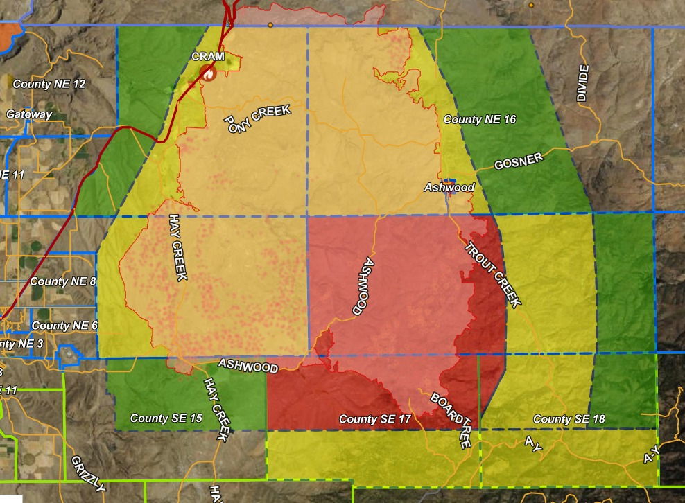
“What a day! Today we downgraded so many zones, the screenshot shows the new area.
Roads are only open to residents in the area, but please be cautious of fire personnel and apparatus in the area.
The bottom Eastern corner of the evacuation levels have not changed. This is the area south of Ashwood. NE 15, SE 17 and SE 18.
The rest of the zones have either been downgraded or completely lifted. Thank you for your patience and as always, THANK YOU to the men and women who have worked tirelessly on the Cram Fire.
Wednesday morning Cram Fire update:
Fire Information Line: (541) 216-7206Email 2025.cram@firenet.govInformation Resources: https://linktr.ee/cramfire2025
Size: 95,736 acres | Cause: Under Investigation | Total Personnel: 662| Containment: 77%
There has been no recent growth of the Cram fire and crews patrolling the fire area yesterday reported only one visible smoke that was far interior to the fire’s edge. Current fire activity is minimal, limited to creeping and smoldering in dead vegetation underneath trees, or heavier fuels well within the interior of the fire.
Today, firefighters will continue to patrol the fire perimeter and structures interior to the fire. They will be checking for and extinguishing any areas of heat, ensuring nothing is left that could reignite. Crews will also be engaged in suppression repair, working to restore soil stability and vegetative cover from areas impacted by suppression-related activities.
Fire activity has decreased significantly, and as containment and suppression repair objectives are met, firefighting resources and excess equipment will be released from the incident and made available to fill other needs.
Weather: Today and tomorrow will be warmer and drier, with high temperatures in the low 80s and humidity close to 20%. Winds will increase in the afternoon, becoming northwesterly and gusting up to 20 mph.
Evacuations: Evacuations remain in effect, but some zones have recently been downgraded and all Evacuations have been lifted in Wasco County. Please refer to official evacuation maps for the most up-to-date info: Jefferson County: tinyurl.com/JCSOEvacMap, Wasco County: tinyurl.com/WascoCountyEvacMap, Crook County: tinyurl.com/CrookCountyEvacMap
Smoke Outlook: An interactive smoke map for your area is available at https://fire.airnow.gov.
Safety: The public plays an important role in preventing the next wildfire; use caution with all ignition sources. For prevention tips, visit https://keeporegongreen.org.
The Jefferson County Sheriff’s Office issued this Facebook post Tuesday afternoon:
“We are still at 73% containment for the Cram Fire, but we have made some more evacuation level updates!
The map reflects the most current changes. Please click the map to see your address in relation to zones and the fire.
MAP: https://fr911orgis.maps.arcgis.com/…/weba…/index.html…
Those that remain in a level three are currently just around the burn perimeter.
Zones dropped to zero:
NE 10
NE 12
NE 8
NE 6
West side of SE 15
SE 16
Thank you for your patience during the Cram Fire. As some teams demobilized and have started to head back home, we want to thank them for all their hard work from helping us spread the message to being on the ground fighting this fire. Everyone contributed so much! Drive safely home back to your families! We still have some teams that remain in the area, so be cautious as you are driving, in case there are fire personnel or apparatus in the area!”
Tuesday’s Butte Creek Fire update:
Butte Creek Fire Update – Tuesday, July 22, 2025
Fire Information Line: (541) 216-7206 8:00 a.m. to 8:00 p.m.
Email 2025.buttecreek@firenet.gov
Size: 2,050 acres | Cause: Undetermined | Total Personnel: 196 | Containment: 30%
Northwest Complex Incident Management Team 3 assumed command of the Butte Creek Fire at 6:00 pm, Monday, July 21.
Butte Creek Fire is about 1.5 miles west of Simnasho, Oregon on the Warm Springs Reservation. The fire is north of Warm Springs and east of highway 26 in the Beaver Creek drainage. Ongoing fire suppression efforts by the Warm Springs Agency Fire Management have been successful; utilizing air and ground resources. The fire is in steep, rugged terrain.
Monday, firefighters implemented strategic firing operations in the Coyote Creek area to minimize the grass, brush and understory on the eastern portion of the fire. Firefighters are working the northern flank toward where the fire drops down into Beaver Creek Drainage and were supported by helicopters doing water drops to limit eastern progression of the fire at the confluence of Beaver and Coyote Creeks.
Success rates are high at this point and resources under Warm Springs management have done a great job to have set the incoming team up well for additional success.
Temperatures are expected to be about ten degrees higher today and northwest winds may gust up to 16 miles per hour. There is a low likelihood of rain showers occurring in the fire area today. Firefighters will continue efforts to hold the fire in Beaver Creek while working on contingency fireline connecting old roads to the north.
Firefighters and equipment assigned to the Butte Creek and Cram Fires are also prepared to provide support for initial attack of new fire starts.
Closures: Closure information for Butte Creek Fire is posted by Warm Springs Police Department at facebook.com/WarmSpringsPoliceDepartment
Evacuations: Evacuation Information for Butte Creek Fire is available at SARTOPO.com/M/jjL6u6k
Facebook: facebook.com/CTWSFireMgt
InciWeb: https://inciweb.wildfire.gov/incident…/orwsa-butte-creek
Fire Information Line: (541) 216-7206, 8:00 a.m. to 8:00 p.m.
Smoke & Air Quality Information: fire.airnow.gov
Meanwhile, as of Monday evening, no evacuations remain on the Warm Springs Evacuation Map for the 381-acre Greeley Heights Fire in Warm Springs