UPDATE: Alder Springs Fire 68% Contained, Final Update Provided as Evacuation Orders Lifted
KTVZ – News Team
JEFFERSON COUNTY, Ore. (KTVZ) — The Alder Springs Fire is now 68% contained with LEVEL 1 evacuation notices in place. Below is the latest from Central Oregon Fire.
Yesterday, wildland firefighters continued to mop up and secure fire lines around the Alder Springs Fire burning on lands managed by the US Forest Service and BLM and protected by Crooked River Ranch Fire and Rescue and the Lower Bridge Rangeland Fire Protection Association. The fire remains within its 3,278 acre footprint and is now 68% contained.
Rain is forecast for the fire area today and mobile weather stations will be measuring and recording precipitation in several locations. Due to increased containment and cooler weekend temperatures, the Jefferson County Sheriff’s Office has made changes to evacuation levels. There are no longer Level 2 and Level 3 evacuation orders in place. Now only Level 1 evacuation notices are in place in Jefferson County for the Alder Springs Fire in the following zones: CRR11, CRR10N, CRR10S, CRR12, CRR8, CRR7, CRR6. For a map of the evacuation zones, visit: https://tinyurl.com/JeffersonCountyEmergencyMap
The Prineville BLM has lifted the closure that was put in place as a result of the Alder Springs Fire as of 6:00 a.m. today, June 21, 2025. The public can now access trailhead and trails for Steelhead Falls, Otter Bench and Scout Camp; however, there is still fire traffic in the area so visitors to these sites are encouraged to use caution while driving and recreating.
While crews will continue to mop up and secure the fire perimeter in the northeast portion of the fire, Resource Advisors (READs) continue to make their assessments and resources have been brought in to assist with suppression repair in the areas along the perimeter that have been contained. READs help advise fire staff on how to protect or mitigate negative impacts to natural and cultural resources. Where firefighters have put in control lines with dozers, skidgens or hand tools, those fire lines will need to be repaired and naturalized so they do not become new roads, trails or paths for increased erosion.
This will be the final fire update for the Alder Springs Fire. The fire will transition to a local Type 4 incident management team on Sunday afternoon. Any updates for the Alder Springs Fire will be posted on the official source for wildfire information in Central Oregon at centraloregonfire.org or on X/Twitter @CentralORfire.
Call 9-1-1 to report a wildfire. For smoke and air quality information visit fire.airnow.gov.
Remember it only takes one spark to cause an accidental wildfire. Know your local fire restrictions, take care with all ignition sources, secure trailer chains and do not drive through or park in dry grass. Preventing wildfires doesn’t just protect public lands, it protects communities so do your part to prevent one more spark.
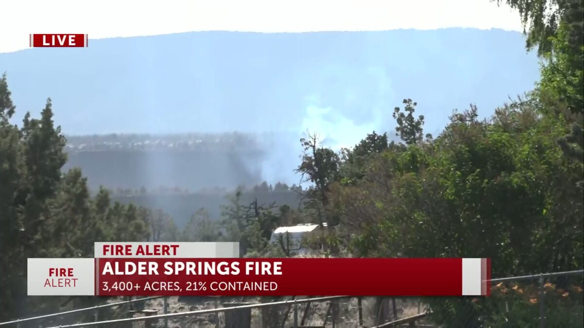
CROOKED RIVER RANCH, Ore. (KTVZ) — The Alder Springs Fire burned across 3,400 acres but reached 40% containment as of Friday as officials report more progress on extinguishing the wildfire while securing lines and sparing hundreds of homes protected by crews from around the state.
The announcement comes after the Jefferson County Sheriff’s Office dropped all Level 3 GO NOW evacuation orders as seen on this interactive map.
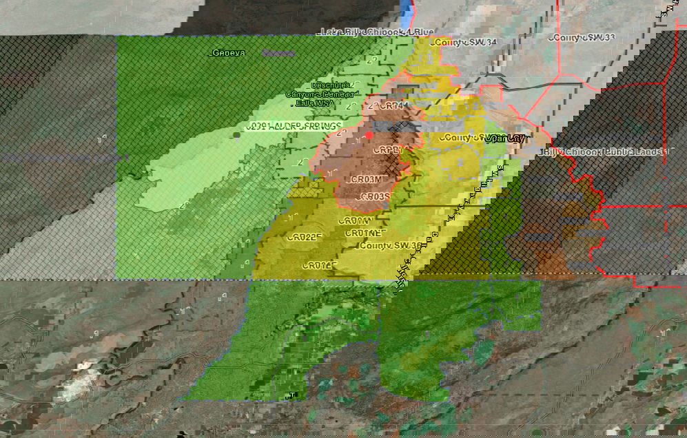 Level 3 GO NOW (red) evacuation orders have been dropped to Level 2 (BE SET – yellow), others reduced to Level 1 (BE SET – green) in revised Jefferson County map Wednesday evening
“Watch out for fire personnel for the next several days,” the sheriff’s Office advised in a Facebook post Wednesday evening. “Even if you return in a Level 2 (BE SET zone), be cautious of smoke and aware fire personnel could be on your property if a flare-up happens near your land.
“Still remain vigilant and be ready to go if anything changes. We appreciate the patience during this fire. Fire personnel have been working diligently day and night to contain this fire which is currently at 21% containment. Thank you to everyone who has assisted in the Alder Springs Fire so far and will continue to do so through the week,” the Facebook post said.
Earlier in an update on the Alder Springs Fire Facebook page, officials said, “Firefighters continue to look for and mop up hotspots along the fire’s edge. As the fire’s edge is proved to be free of all burn potential, the containment percentage will continue to increase.”
The Northwest Coordination Center reported earlier Wednesday that 2,052 homes were threatened by the blaze and 1,279 other “minor structures.”
Friday Update:
Containment levels have increased. The Alder Springs Fire is now 40% contained with no new growth.
Thank you for your patience and understanding as firefighters remain in the area to ensure the community stays protected. Please stay alert for any changes.
Wednesday Update:
Alder Springs Fire Information: 503-383-9647Jefferson County Sheriff’s Office Evacuation Information: 541-420-9652Alder Springs Fire Facebook Page: Facebook.com/AlderSpringsFire
Central Oregon —Yesterday, wildland firefighters were successful in increasing containment on the Alder Springs Fire burning on lands managed by the US Forest Service and BLM and protected by Crooked River Ranch Fire and Rescue and the Lower Bridge Rangeland Fire Protection Association. The Oregon State Fire Marshal (OSFM) task forces completed their structure protection and mop up work in and around Crooked River Ranch. The Alder Springs Fire footprint remains 3,278 acres and is now 40% contained.
“On behalf of the Forest Service and BLM, we would like to thank the Central Oregon Interagency Management Type 3 Team, the Oregon State Fire Marshal’s Red Team, and all our cooperators and partners for coming together as one team with one mission,” said Crooked River National Grassland District Ranger, Slater Turner.
“We are very proud of our firefighters whose aggressive attack of this fire helped return our community back into their homes,” said Lisa Clark, Field Manager with the Prineville BLM Deschutes Field Office. “The OSFM and Central Oregon teams showed a high level of professionalism and provided the public with helpful, up-to-date information that was critical to the success of this incident. We are grateful for all the hard work and planning that helped keep firefighters and the public safe during this early season fire.”
All OSFM structural task forces are demobilizing today. The last two task forces will finish their work this morning before heading to their home department.
“The Red Team is deeply grateful for the opportunity to serve the Crooked River Ranch community — your support means everything,” said Incident Commander Ian Yocum.
Wildland firefighters are back on the fire this morning, continuing to mop up to reach the goal of 100 ft of cold ground all the way around the fire perimeter. Crews will continue to use Unmanned Aircraft Systems (UAS) also known as “drones” equipped with infrared (IR) technology to identify areas of heat both on the perimeter, as well as areas of more dense heat on the fire interior. Fire Managers are also working with Resource Advisors (READs) to begin to assess the needs for suppression repair. Where firefighters have put in control lines with dozers, skidgens or hand tools, those fire lines will need to be repaired and naturalized so they do not become new roads, trails or paths for increased erosion. READs help advise fire staff on how to complete to protect or mitigate negative impacts to natural and cultural resources.
With cooler temperatures and moisture forecast for today and this weekend, some wildland resources are being released from the fire to return to their homes and families so they can rest and be available for future fires.
The Alder Springs Fire was human-caused and the investigation is on-going. More information will be released when the investigation is complete.
Evacuations: The Jefferson and Deschutes County Sheriff’s Offices have issued evacuation notices for the Alder Springs Fire. Level 2-Set: CR06, CR07, CR08, CR10N, CR10S, CR11, CR12Level 1-Ready: CR02M, CR02N, CRPL2
For more information on evacuation notices, visit:Deschutes County Evacuation Map: https://tinyurl.com/DeschutesCountyEmergencyJefferson County Evacuation Map: https://tinyurl.com/JeffersonCountyEmergencyMap
A temporary evacuation point has been established at Highland Baptist Church: 3100 SW Highland Avenue, Redmond. A large animal shelter has been established at the Deschutes County Fairgrounds at 3800 SW Airport Way, Redmond.